Back المسمية الصغيرة Arabic المسميه الصغيره ARZ מסמיה HE Al-Masmiyya al-Saghira ID Al-Masmija as-Saghira Polish المسمیہ الصغیرہ Urdu
al-Masmiyya al-Saghira
المسمية الصغيرة Masmiyyat al-Hurani al-Huraniyya | |
|---|---|
Village | |
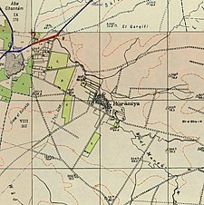
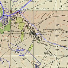
A series of historical maps of the area around Al-Masmiyya al-Saghira (click the buttons) | |
Location within Mandatory Palestine | |
| Coordinates: 31°45′10″N 34°47′56″E / 31.75278°N 34.79889°E | |
| Palestine grid | 131/128 |
| Geopolitical entity | Mandatory Palestine |
| Subdistrict | Gaza |
| Date of depopulation | July 8–9, 1948[3] |
| Area | |
| • Total | 6,478 dunams (6.478 km2 or 2.501 sq mi) |
| Population (1945) | |
| • Total | 530[1][2] |
| Cause(s) of depopulation | Military assault by Yishuv forces |
| Current Localities | Masmiya Bet,[4] Kfar HaRif[5] |
Al-Masmiyya al-Saghira (Arabic: المسمية الصغيرة), also known as Mamsiyyat al-Hurani, was a Palestinian Arab village in the Gaza Subdistrict, located 42 kilometers (26 mi) northeast of Gaza. Established in the 19th century,[5] it was situated at an elevation of 60 meters (200 ft) in the southern coastal plain of Ottoman Syria. Al-Masmiyya al-Saghira was depopulated during the 1948 Arab-Israeli War, but prior to that, in 1945, it had a population of 530 inhabitants.[5]
- ^ Government of Palestine, Department of Statistics, 1945, p. 32
- ^ a b Government of Palestine, Department of Statistics. Village Statistics, April, 1945. Quoted in Hadawi, 1970, p. 46
- ^ Morris, 2004, p. xix, village #274. Also gives the cause for depopulation.
- ^ also known as Masmiya Shalom. Morris, 2004, p. xxi, settlement #72, established in 1949
- ^ a b c Khalidi, 1992, p. 126
© MMXXIII Rich X Search. We shall prevail. All rights reserved. Rich X Search


