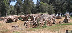
Al-Mirr
المرّ / المحمودية Molendina desubter Mirabellum | |
|---|---|
 Remains of Mill building | |
| Etymology: "The passage".[1] | |
A series of historical maps of the area around Al-Mirr (click the buttons) | |
Location within Mandatory Palestine | |
| Coordinates: 32°06′43″N 34°54′57″E / 32.11194°N 34.91583°E | |
| Palestine grid | 142/168 |
| Geopolitical entity | Mandatory Palestine |
| Subdistrict | Jaffa |
| Date of depopulation | February or March, 1948[4] |
| Area | |
| • Total | 51 dunams (5.1 ha or 13 acres) |
| Population (1945) | |
| • Total | 170[2][3] |
| Cause(s) of depopulation | Fear of being caught up in the fighting |
Al-Mirr, also named Mahmudiyeh ("the property of Mahmud"),[1] was a Palestinian Arab village in the Jaffa Subdistrict, which was depopulated during the 1947–1948 Civil War in Mandatory Palestine on February 1, 1948.
© MMXXIII Rich X Search. We shall prevail. All rights reserved. Rich X Search


