Back ألبرت ليا Arabic البرت ليا ARZ آلبرت لی، مینهسوتا AZB Albert Lea Catalan Альберт-Ли (Миннесота) CE Albert Lea CEB Albert Lea DAG Albert Lea German Albert Lea Spanish Albert Lea (Minnesota) Basque
Albert Lea, Minnesota | |
|---|---|
 The historic downtown | |
| Motto: Land Between the Lakes | |
 | |
| Coordinates: 43°39′18″N 93°21′51″W / 43.65500°N 93.36417°W | |
| Country | United States |
| State | Minnesota |
| County | Freeborn |
| Founded | 1855 |
| Incorporated (village) | 1859 |
| Incorporated (city) | 1878 |
| Government | |
| • Mayor | Rich Murray |
| • City Manager | Ian Rigg |
| • City Attorney | Kelly Martinez |
| • Public Safety Director | JD Carlson |
| Area | |
| • City | 15.14 sq mi (39.21 km2) |
| • Land | 13.29 sq mi (34.42 km2) |
| • Water | 1.85 sq mi (4.79 km2) 12.69% |
| Elevation | 1,247 ft (380 m) |
| Population | |
| • City | 18,492 |
| • Estimate (2022)[4] | 18,396 |
| • Density | 1,391.53/sq mi (537.27/km2) |
| • Urban | 17,992 |
| • Metro | 30,718 (US: 428th) |
| • Demonym | Albert Leans |
| Time zone | UTC-6 (CST) |
| • Summer (DST) | UTC-5 (CDT) |
| ZIP Code | 56007 |
| Area code | 507 |
| FIPS code | 27-00694 |
| GNIS feature ID | 2393902[2] |
| Website | cityofalbertlea.org |
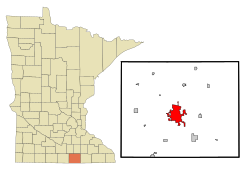
Albert Lea (/ˌælbərt ˈliː/ AL-bərt LEE)[5] is a city in Freeborn County, in southern Minnesota.[6] It is the county seat. Its population was 18,492 at the 2020 census.[3]
The city is at the junction of Interstates 35 and 90, about 90 miles (140 km) south of the Twin Cities. It is on the shores of Fountain Lake, Pickerel Lake, Albert Lea Lake, Goose Lake, School Lake, and Lake Chapeau. Fountain Lake and Albert Lea Lake are part of the Shell Rock River flowage.
The city's early growth was based on agriculture, farming support services and manufacturing, and it was a significant rail center. At one time it was the site of Cargill's headquarters.[7] Other manufacturing included Edwards Manufacturing (barn equipment), Scotsman Ice Machines, Streater Store fixtures, and Universal Milking Machines. As in many U.S. cities, Albert Lea's manufacturing base has substantially diminished. A major employer was the Wilson & Company meatpacking plant, later known as Farmstead and Farmland. This facility was destroyed by fire in July 2001.
- ^ "2020 U.S. Gazetteer Files". United States Census Bureau. Retrieved July 24, 2022.
- ^ a b U.S. Geological Survey Geographic Names Information System: Albert Lea, Minnesota
- ^ a b "Explore Census Data". United States Census Bureau. Retrieved January 17, 2024.
- ^ Cite error: The named reference
USCensusEst2022was invoked but never defined (see the help page). - ^ "Minnesota Pronunciation Guide". Associated Press. Archived from the original on July 22, 2011. Retrieved July 4, 2011.
- ^ "Find a County". National Association of Counties. Archived from the original on May 31, 2011. Retrieved June 7, 2011.
- ^ "Cargill Timeline". cargill.com. Retrieved September 3, 2020.
© MMXXIII Rich X Search. We shall prevail. All rights reserved. Rich X Search