Back Selva montana de la falla Albertina Catalan Bergwälder im Westlichen Rift German Albert-riftaj montarbaroj Esperanto Selva montana de la falla Albertina Spanish Forêts d'altitude du rift Albertin French Foreste montane della faglia albertina Italian Montane bossen van het Albertine Rift Dutch Fjellskogene i Albertineriften NB Горные леса рифта Альбертин Russian Гірські ліси Альбертінського рифту Ukrainian
| Albertine Rift montane forests Forêts montagnardes du Rift Albertin | |
|---|---|
 | |
 Ecoregion territory (in yellow) | |
| Ecology | |
| Biome | Tropical and subtropical moist broadleaf forests |
| Borders | |
| Bird species | 732[1] |
| Mammal species | 228[1] |
| Geography | |
| Area | 103,900 km2 (40,100 sq mi) |
| Countries | |
| Coordinates | 2°45′S 29°08′E / 2.75°S 29.14°E |
| Conservation | |
| Habitat loss | 27.433%[1] |
| Protected | 12.48%[1] |
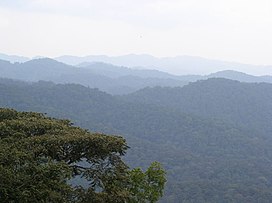
The Albertine Rift montane forests (French: Forêts montagnardes du Rift Albertin) is a tropical moist broadleaf forest ecoregion in east-central Africa. The ecoregion covers the mountains of the northern Albertine Rift, and is home to distinct Afromontane forests with high biodiversity.[2][3][4]
- ^ a b c d Hoekstra, J. M.; Molnar, J. L.; Jennings, M.; Revenga, C.; Spalding, M. D.; Boucher, T. M.; Robertson, J. C.; Heibel, T. J.; Ellison, K. (2010). Molnar, J. L. (ed.). The Atlas of Global Conservation: Changes, Challenges, and Opportunities to Make a Difference. University of California Press. ISBN 978-0-520-26256-0.
- ^ "Map of Ecoregions 2017". Resolve. Retrieved August 20, 2021.
- ^ Cite error: The named reference
dopawas invoked but never defined (see the help page). - ^ "Albertine Rift montane forests". The Encyclopedia of Earth. Retrieved August 20, 2021.
© MMXXIII Rich X Search. We shall prevail. All rights reserved. Rich X Search