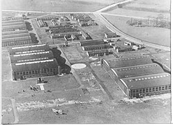
Alexandra Park Aerodrome | |
|---|---|
 Photograph of the aerodrome in 1923 looking west over the two sets of large triple Belfast Truss hangars | |
| Summary | |
| Airport type | Public |
| Owner | Egerton Estate (operated post First World War by Manchester Corporation) |
| Serves | Manchester |
| Location | junction of Princess Road and Mauldeth Road West |
| Coordinates | 53°26′11″N 2°15′01″W / 53.4364°N 2.2502°W |
| Map | |
A grass airfield used by the military during the First World War and as a civilian airport after the war | |
Alexandra Park Aerodrome was the second purpose-built aerodrome in the Manchester area in England. The site was chosen by the War Department in 1917 because of its open agricultural nature, and lay between the neighbouring districts of Fallowfield, Chorlton-cum-Hardy, Whalley Range, Withington and West Didsbury, at the junction of Princess Road and Mauldeth Road West, three miles south of Manchester's city centre: the land was owned by the Egerton Estate.[1] The aerodrome's brief existence is commemorated on a plaque in the sports pavilion at Hough End Playing Fields, which now occupy part of the site. A commemorative plaque was unveiled on 7 July 2007 to mark the 90th anniversary of the aerodrome and is located in the grounds of No. 184 (Manchester South) Squadron, Air Cadets, in Hough End Crescent.
- ^ Scholefield 2004, p. 216
© MMXXIII Rich X Search. We shall prevail. All rights reserved. Rich X Search


