Back الصحراء الجزائرية Arabic الصحرا الجزايريه ARZ Əlcəzair səhrası Azerbaijani Алжырская пустыня Byelorussian Алжирска пустиня Bulgarian Alžírská poušť Czech Algerische Sahara German Sáhara argelino Spanish صحرای الجزایر Persian Sahara algérien French
| Algerian Desert الصحراء الجزائرية | |
|---|---|
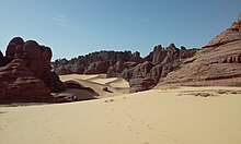
 Sand dunes of Algeria | |
 Map of the Algerian arid desert | |
| Geography | |
| Country | |
| Climate type | Arid desert |


The Algerian Desert (Arabic: الصحراء الجزائرية, romanized: al-Saḥrā' al-Jazā'iriyah) is a desert located in central North Africa within Algeria, constituting part of the Sahara. The desert covers more than 90% of Algeria's total area.[1] In 2018, it was home to a population of 3,600,000 inhabitants, or 10.5% of the Algerian population.[2]
Its expansion starts from the Saharan Atlas as a stony desert, gradually changing into a sand dune desert inland. The plateau of the Tassili n'Ajjer is located in the southeast, and its outstanding collection of prehistoric rock art saw it added to the UNESCO World Heritage List in 1982.[3] Cities and towns such as Ouargla, Adrar, and particularly In Salah are among the hottest places in the Sahara. Annual average rainfall is well above 100 mm (3.9 in) in the northernmost part but the center and the southern part receive much less than 50 mm (2.0 in).
- ^ "Earth from Space: Algerian sands". www.esa.int. Retrieved 2023-08-31.
- ^ Kouzmine, Yaël; Fontaine, Jacques (2018-04-18). "Démographie et urbanisation au Sahara algérien à l'aube du XXIe siècle" [Demography and urbanization in the Algerian Sahara at the dawn of the 21st century]. The EMAM Notebooks. Studies on the Arab World and the Mediterranean (in French) (30). doi:10.4000/emam.1426. ISSN 1969-248X.
- ^ "Tassili n'Ajjer - UNESCO World Heritage Centre". Whc.unesco.org. Retrieved 2013-03-18.
© MMXXIII Rich X Search. We shall prevail. All rights reserved. Rich X Search