Back الونيسوس ARZ Alónnissos Catalan Nisí Alónnisos CEB Alonnisos Czech Alónissos Danish Alonnisos German Αλόννησος Greek Alónnisos Spanish Alónnisos Finnish Alonissos French
Alonnisos
Αλόννησος | |
|---|---|
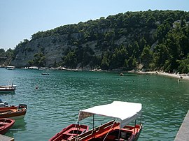
 Port of Alonnisos | |
| Coordinates: 39°9′N 23°50′E / 39.150°N 23.833°E | |
| Country | Greece |
| Administrative region | Thessaly |
| Regional unit | Sporades |
| Area | |
| • Municipality | 129.6 km2 (50.0 sq mi) |
| Highest elevation | 476 m (1,562 ft) |
| Lowest elevation | 0 m (0 ft) |
| Population (2021)[1] | |
| • Municipality | 3,138 |
| • Density | 24/km2 (63/sq mi) |
| Time zone | UTC+2 (EET) |
| • Summer (DST) | UTC+3 (EEST) |
| Postal code | 370 05 |
| Area code(s) | 24240 |
| Vehicle registration | BO |
| Website | www.alonissos.gov.gr |
Alonnisos (Greek: Αλόννησος [aˈlonisos]), also transliterated as Alonissos, is a Greek island in the Aegean Sea. After Skiathos and Skopelos it is the third member of the Northern Sporades. It is 3 km (2 mi) (2 nm) east of the island of Skopelos. Alonnisos is also the name of a village on the island, as well as the municipality that encompasses the island and the village.
The village of Alonnisos is located on the southern part of the island. It is locally known as Chora and signposted as The Old Village. The main port of the island is located in the southeast and is called Patitiri. There are ferry, catamaran ("flying cat") and hydrofoil ("flying dolphin") services from Patitiri to Volos, Agios Konstantinos, and Thessaloniki on the mainland and to the islands of Skiathos, Skopelos and Skyros. The bay at the southern end of the island is also called Alonnisos.
The Municipality of Alonnisos includes the nearby islands of Adelfoi, Gioura, Kyra Panagia (Pelagos), Peristera, Piperi, Psathoura and Skantzoura.
- ^ "Αποτελέσματα Απογραφής Πληθυσμού - Κατοικιών 2021, Μόνιμος Πληθυσμός κατά οικισμό" [Results of the 2021 Population - Housing Census, Permanent population by settlement] (in Greek). Hellenic Statistical Authority. 29 March 2024.
© MMXXIII Rich X Search. We shall prevail. All rights reserved. Rich X Search

