Back Alpthal ALS Alpthal Catalan Alpthal (munisipyo) CEB Alpthal Czech Альпталь CV Alpthal German Alpthal Esperanto Alpthal Spanish Alpthal Basque Alpthal French
Alpthal | |
|---|---|
 | |
| Coordinates: 47°4.2′N 8°42.9′E / 47.0700°N 8.7150°E | |
| Country | Switzerland |
| Canton | Schwyz |
| District | Schwyz |
| Area | |
| • Total | 22.90 km2 (8.84 sq mi) |
| Elevation (Kirche Alpthal) | 996 m (3,268 ft) |
| Population (31 December 2018)[2] | |
| • Total | 616 |
| • Density | 27/km2 (70/sq mi) |
| Time zone | UTC+01:00 (Central European Time) |
| • Summer (DST) | UTC+02:00 (Central European Summer Time) |
| Postal code(s) | 8849 |
| SFOS number | 1361 |
| ISO 3166 code | CH-SZ |
| Localities | Eigen, Alpthal, Brunni, Holzegg |
| Surrounded by | Einsiedeln, Oberiberg, Rothenthurm, Schwyz |
| Website | www SFSO statistics |
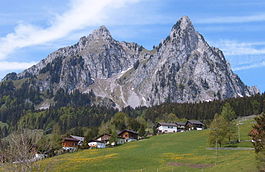
Alpthal is a village and municipality in Schwyz District in the canton of Schwyz in Switzerland. Besides the village of Alpthal, the municipality includes the ski resort of Brunni, and settlement of Eigen.[3]
- ^ a b "Arealstatistik Standard - Gemeinden nach 4 Hauptbereichen". Federal Statistical Office. Retrieved 13 January 2019.
- ^ "Ständige Wohnbevölkerung nach Staatsangehörigkeitskategorie Geschlecht und Gemeinde; Provisorische Jahresergebnisse; 2018". Federal Statistical Office. 9 April 2019. Retrieved 11 April 2019.
- ^ map.geo.admin.ch (Map). Swiss Confederation. Retrieved 3 July 2015.
© MMXXIII Rich X Search. We shall prevail. All rights reserved. Rich X Search


