Back Amrum Afrikaans جزيرة أمروم Arabic جزيره امروم ARZ Амрум Bulgarian Amrum Breton Amrum Catalan Amrum CEB Amrum Danish Amrum German Amrum Esperanto
This article needs additional citations for verification. (July 2019) |
Native name: Oomram | |
|---|---|
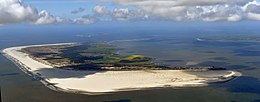
 Aerial view of Amrum | |
 | |
| Geography | |
| Location | Wadden Sea |
| Coordinates | 54°39′N 8°21′E / 54.650°N 8.350°E |
| Archipelago | North Frisian Islands |
| Major islands | Sylt, Föhr, Amrum |
| Area | 20.46 km2 (7.90 sq mi) |
| Highest elevation | 32 m (105 ft) |
| Highest point | Siatler |
| Administration | |
Germany | |
| State | Schleswig-Holstein |
| District | Nordfriesland |
| Demographics | |
| Population | 2,354 (2013[1]) |
| Pop. density | 111/km2 (287/sq mi) |
| Ethnic groups | Germans, Frisians |
Amrum (German pronunciation: [ˈamʁʊm] ; Öömrang North Frisian: Oomram) is one of the North Frisian Islands on the German North Sea coast, south of Sylt and west of Föhr. It is part of the Nordfriesland district in the federal state of Schleswig-Holstein and has approximately 2,300 inhabitants.
The island is made up of a sandy core of geestland and features an extended beach all along its west coast, facing the open North Sea. The east coast borders to mudflats of the Wadden Sea. Sand dunes are a characteristic part of Amrum's landscape, resulting in a vegetation that is largely made up of heath and shrubs. The island's only forest was planted in 1948. Amrum is a refuge for many species of birds and a number of marine mammals including the grey seal and harbour porpoise.
Settlements on Amrum have been traced back to the Neolithic period when the area was still a part of the mainland of the Jutland peninsula. During the Middle Ages, Frisian settlers arrived at Amrum and engaged in salt making and seafaring. A part of the modern population still speaks Öömrang, a dialect of the North Frisian language, and Frisian traditions are kept alive.
With the island hosting many endangered species of plants and animals, its soil being largely unproductive for agriculture and as a popular seaside resort in general, Amrum's population today almost exclusively lives from the tourism industry.
© MMXXIII Rich X Search. We shall prevail. All rights reserved. Rich X Search