Back غابة انجلينا الوطنيه ARZ Bosc Nacional Angelina Catalan Angelina National Forest CEB Angelina National Forest German Bosque nacional de Angelina Spanish Forêt nationale d'Angelina French ആഞ്ജലീന ദേശീയ വനം Malayalam 安吉丽娜国家森林 Chinese
| Angelina National Forest | |
|---|---|
 | |
| Location | Texas, USA |
| Nearest city | Lufkin, TX |
| Coordinates | 31°16′07″N 94°24′43″W / 31.26861°N 94.41194°W |
| Area | 153,180 acres (619.9 km2)[1] |
| Established | October 13, 1936[2] |
| Governing body | U.S. Forest Service |
| Website | National Forests in Texas |


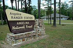
Angelina National Forest is a United States National Forest, one of four located in the piney woods region of Texas. The 153,180-acre (619.9 km2)[1] Angelina National Forest is located in East Texas in parts of San Augustine, Angelina, Jasper and Nacogdoches counties.[1] It is managed together with the three other National Forests in Texas (Davy Crockett, Sabine, and Sam Houston) from Forest Service offices in Lufkin, Texas. There are local district offices located in Zavalla. The forest lies in the Neches River Basin and on the north and south shores of Sam Rayburn Reservoir. Longleaf pine is the predominant cover type in the southern portion of the forest, while loblolly and shortleaf pine are dominant species in the northern portion and abundant throughout.
- ^ a b c "Land Areas of the National Forest System" (PDF). U.S. Forest Service. Retrieved 2012-03-20.
- ^ "The National Forests of the United States" (PDF). ForestHistory.org. Retrieved July 30, 2012.
© MMXXIII Rich X Search. We shall prevail. All rights reserved. Rich X Search
