Back خط السير الأنطونيوسي Arabic Итинерариум на Антонин Bulgarian Itinerarium Antonini Breton Itinerari d'Antoní Catalan Itinerarium Antonini German Itinero de Antonino Esperanto Itinerario de Antonino Spanish Antoninoren Ibilbidea Basque Itinéraire d'Antonin French Itinerario de Antonino Galician

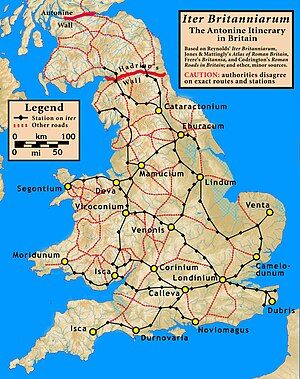
The Antonine Itinerary (Latin: Itinerarium Antonini Augusti, "Itinerary of the Emperor Antoninus") is an itinerarium, a register of the stations and distances along various roads. Seemingly based on official documents, possibly in part from a survey carried out under Augustus, it describes the roads of the Roman Empire.[1] Owing to the scarcity of other extant records of this type, it is a valuable historical record.[2]
Almost nothing is known of its author or the conditions of its compilation. Numerous manuscripts survive, the eight oldest dating to some point between the 7th to 10th centuries after the onset of the Carolingian Renaissance.[3] Despite the title seeming to ascribe the work to the patronage of the 2nd-century Antoninus Pius, all surviving editions seem to trace to an original towards the end of the reign of Diocletian in the early 4th century.[3] The most likely imperial patron—if the work had one—would have been Caracalla.[1]
- ^ a b One or more of the preceding sentences incorporates text from a publication now in the public domain: Chisholm, Hugh, ed. (1911). "Antonini Itinerarium". Encyclopædia Britannica. Vol. 2 (11th ed.). Cambridge University Press. p. 148.
- ^ Rivet, A. L. F.; Jackson, Kenneth (1970). "The British Section of the Antonine Itinerary". Britannia. 1: 34–82. doi:10.2307/525833. JSTOR 525833. S2CID 162217811.
- ^ a b Öberg (2023), p. 5.
© MMXXIII Rich X Search. We shall prevail. All rights reserved. Rich X Search