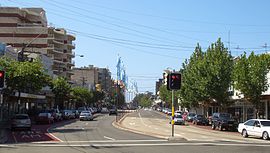
Anzac Parade | |
|---|---|
 | |
| Bunnerong Road ,Kingsford | |
| Coordinates | |
| General information | |
| Type | Road |
| Length | 13.5 km (8.4 mi)[1] |
| Opened | 1917 |
| Gazetted | August 1928[2] |
| Former route number | |
| Major junctions | |
| North end | Flinders Street Moore Park, Sydney |
| |
| South end | No through road La Perouse, Sydney |
| Location(s) | |
| Major suburbs | Kensington, Kingsford, Maroubra, Matraville, Malabar, Chifley, Little Bay |
| ---- | |

Anzac Parade is a major road in the south-eastern suburbs of Sydney, Australia which travels south-east from the CBD, named in memory of members of the First Australian Imperial Force (later to become known as Anzacs) who marched down the street from their barracks (now a heritage listed part of the University of New South Wales) to Sydney Harbour, where they were transported to Europe during World War I.
- ^ Google (17 August 2022). "Anzac Parade" (Map). Google Maps. Google. Retrieved 17 August 2022.
- ^ "Main Roads Act, 1924-1927". Government Gazette of the State of New South Wales. No. 110. National Library of Australia. 17 August 1928. pp. 3814–20. Archived from the original on 3 August 2022. Retrieved 1 August 2022.
© MMXXIII Rich X Search. We shall prevail. All rights reserved. Rich X Search

