Back خليج أبالاتشيكولا Arabic Apalachicola Bay CEB Bahía Apalachicola Spanish アパラチコーラ湾 Japanese Sinus Apalachicola Latin
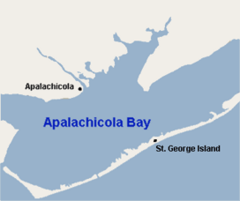
Apalachicola Bay is an estuary and lagoon located on the northwest coast of the U.S. state of Florida. The Apalachicola Bay system also includes St. George Sound, St. Vincent Sound and East Bay, covering an area of about 208 square miles (540 km2).[1] Four islands, St. Vincent Island to the west, Cape St. George Island and St. George Island to the south, and Dog Island to the east, separate the system from the Gulf of Mexico.[2] Water exchange occurs through Indian Pass, West Pass, East Pass and the Duer Channel. The lagoon has been designated as a National Estuarine Research Reserve and the Apalachicola River is the largest source of freshwater to the estuary.[2] Combined with the Chattahoochee River, Flint River, and Ochlockonee River they drain a watershed of over 20,000 square miles (50,000 km2) at a rate of 19,599 cubic feet (550 m3) per second according to the United States Geological Survey in 2002.[1][3]

- ^ a b "Geographic Names Information System". edits.nationalmap.gov. Retrieved 2021-11-12.
- ^ a b "Florida Department of Environmental Protection: Learn about Your Watershed Apalachicola River-Chipola River Watershed". Protecting Your Water. My Florida. 2009. Archived from the original on 2009-10-05. Retrieved 2023-12-20.
{{cite web}}: CS1 maint: unfit URL (link) - ^ "The Apalachicola National Estaurine Reserve" (PDF). coast.noaa.gov. 2021. Archived (PDF) from the original on 2017-05-02.
© MMXXIII Rich X Search. We shall prevail. All rights reserved. Rich X Search