Back Appin CEB Masacre de Appin Spanish آپین، نیو ساوت ولز Persian Appin (Australie) French Appin Polish Appin Portuguese Appin, New South Wales SIMPLE Appin, New South Wales Swedish اپین، نیو ساؤتھ ویلز Urdu 阿平 (新南威尔士州) Chinese
| Appin New South Wales | |||||||||||||||
|---|---|---|---|---|---|---|---|---|---|---|---|---|---|---|---|
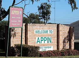
 Northern entry to Appin | |||||||||||||||
| Coordinates | 34°12′S 150°47′E / 34.200°S 150.783°E | ||||||||||||||
| Population | 3,213 (2021 census)[1] | ||||||||||||||
| Postcode(s) | 2560 | ||||||||||||||
| Elevation | 240 m (787 ft) | ||||||||||||||
| Location |
| ||||||||||||||
| LGA(s) | Wollondilly Shire | ||||||||||||||
| Region | Macarthur | ||||||||||||||
| State electorate(s) | Wollondilly | ||||||||||||||
| Federal division(s) | Hume | ||||||||||||||
| |||||||||||||||
Appin is a town on the south-west fringe of Sydney in the Macarthur Region in Tharawal country near its boundary with Gandangara country, New South Wales, Australia in Wollondilly Shire. It is situated about 16 kilometres (9.9 mi) south of Campbelltown and 35 kilometres (22 mi) northwest of Wollongong.
- ^ Australian Bureau of Statistics (28 June 2022). "Appin (NSW)". 2021 Census QuickStats. Retrieved 5 September 2022.
© MMXXIII Rich X Search. We shall prevail. All rights reserved. Rich X Search
