Back نهر أبوماتوكس Arabic نهر ابوماتوكس ARZ Appomattox River CEB Appomattox River German Appomattox River French Appomattox (rivier) Dutch Appomattox (rzeka) Polish Аппоматтокс (река) Russian
| Appomattox River | |
|---|---|
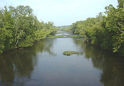
 The Appomattox River at Matoaca, Virginia | |
 Map of the James River watershed with the Appomattox River watershed highlighted light yellow; the Appomattox River is shown in dark blue | |
| Location | |
| Country | United States |
| State | Virginia |
| Cities | Petersburg, Tri-cities |
| Physical characteristics | |
| Source | |
| • location | Appomattox, Virginia |
| • coordinates | 37°23′46″N 78°49′44″W / 37.39614°N 78.82888°W[1] |
| • elevation | 820 ft (250 m)[2] |
| Mouth | James River |
• location | Hopewell, Virginia |
• coordinates | 37°19′15″N 77°16′32″W / 37.32083°N 77.27556°W[1] |
• elevation | 0 ft (0 m)[2] |
| Length | 157 mi (253 km)[1] |
| Basin size | 1,344 sq mi (3,480 km2)[3] |
| Discharge | |
| • location | Matoaca[3] |
| • average | 1,366 cu ft/s (38.7 m3/s)[3] |
| • minimum | 18 cu ft/s (0.51 m3/s) |
| • maximum | 39,400 cu ft/s (1,120 m3/s) |
The Appomattox River is a tributary of the James River, approximately 157 miles (253 km) long,[4] in central and eastern Virginia, named for the Appomattocs Indian tribe who lived along its lower banks in the 17th century. It drains a cotton and tobacco-growing region of the Piedmont and coastal plain southwest of Richmond.
- ^ a b c "Appomattox River". Geographic Names Information System. United States Geological Survey, United States Department of the Interior. Retrieved July 26, 2023.
- ^ a b Google Earth elevation for GNIS coordinates.
- ^ a b c James River Basin, from Water Resources Data Virginia Water Year 2005, USGS.
- ^ U.S. Geological Survey. National Hydrography Dataset high-resolution flowline data. The National Map Archived 2012-03-29 at the Wayback Machine, accessed April 1, 2011
© MMXXIII Rich X Search. We shall prevail. All rights reserved. Rich X Search