Back اریواکا، آریزونا AZB Аривака (Аризона) CE Arivaca (lungsod sa Tinipong Bansa) CEB Arivaca (Arizona) Spanish اریواکا، آریزونا Persian Arivaca French Arivaca, Arizona Croatian Arivaca, Arizona HT Arivaca Italian Arivaca (Arizona) LLD
Arivaca, Arizona | |
|---|---|
 Arivaca, facing west down Main Street, 2015 | |
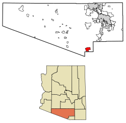
 Location of Arivaca in Pima County, Arizona. | |
| Coordinates: 31°34′38″N 111°19′53″W / 31.57722°N 111.33139°W | |
| Country | United States |
| State | Arizona |
| County | Pima |
| Area | |
| • Total | 27.78 sq mi (71.94 km2) |
| • Land | 27.78 sq mi (71.94 km2) |
| • Water | 0.00 sq mi (0.00 km2) |
| Elevation | 3,643 ft (1,110 m) |
| Population (2020) | |
| • Total | 623 |
| • Density | 22.43/sq mi (8.66/km2) |
| Time zone | MST (no DST) |
| FIPS code | 04-03320 |
Arivaca (O'odham: Ali Wa:pk) is an unincorporated community in Pima County, Arizona, United States.[2] It is located 11 miles (18 km) north of the Mexican border and 35 miles (56 km) northwest of the port of entry at Nogales. The European-American history of the area dates back at least to 1695, although the community was not founded until 1878.[2] Arivaca has the ZIP code 85601.[3] The 85601 ZIP Code Tabulation Area had a population of 909 at the 2000 census.[4]
- ^ "2020 U.S. Gazetteer Files". United States Census Bureau. Retrieved October 29, 2021.
- ^ a b Arivaca Archived September 17, 2007, at the Wayback Machine, Arizona Department of Commerce, August 10, 2007. Accessed 2007-09-07.
- ^ "Zip Code Lookup". Archived from the original on June 15, 2011.
- ^ "U.S. Census website". United States Census Bureau. Retrieved January 31, 2008.
© MMXXIII Rich X Search. We shall prevail. All rights reserved. Rich X Search

