Back Armour Square French Armour Square Portuguese Armour Square, Chicago SIMPLE Armor Skver (Čikago) Serbian
Armour Square | |
|---|---|
| Community Area 34 - Armour Square | |
 Chinatown neighborhood within Armour Square. | |
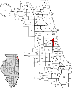
 Map of Armour Square | |
 Location within the city of Chicago | |
| Coordinates: 41°50′24″N 87°37′59″W / 41.8400333°N 87.6331070°W[1] | |
| Country | United States |
| State | Illinois |
| County | Cook |
| City | Chicago |
| Neighborhoods | |
| Area | |
| • Total | 0.99 sq mi (2.56 km2) |
| Elevation | 587 ft (179 m) |
| Population (2020) | |
| • Total | 13,890 |
| • Density | 14,000/sq mi (5,400/km2) |
| Demographics 2020[2] | |
| • White | 14.0% |
| • Black | 8.9% |
| • Hispanic | 5.6% |
| • Asian | 70.7% |
| • Other | 0.9% |
| Time zone | UTC-6 (CST) |
| • Summer (DST) | UTC-5 (CDT) |
| ZIP codes | parts of 60609 and 60616 |
| Median household income 2020[2] | $37,123 |
| Source: U.S. Census, Record Information Services | |
Armour Square is a Chicago neighborhood on the city's South Side, as well as a larger, officially defined community area, which also includes Chinatown and the CHA Wentworth Gardens housing project. Armour Square is bordered by Bridgeport to the west, Pilsen to the northwest, Douglas and Grand Boulevard to the east and southeast, and with the Near South Side bordering the area to the north, and Fuller Park bordering its southernmost boundary, along Pershing Road.
- ^ a b "Armour Square". Geographic Names Information System. United States Geological Survey, United States Department of the Interior. May 15, 1997.
- ^ a b "Community Data Snapshot - Armour Square" (PDF). MetroPulse. Retrieved July 11, 2020.
© MMXXIII Rich X Search. We shall prevail. All rights reserved. Rich X Search