Back مقاطعة أروستوك (مين) Arabic Aroostook County, Maine BAR Арустук (акруга) Byelorussian Арустук (окръг) Bulgarian আরোস্টক কাউন্টি, মেইন BPY Comtat d'Aroostook (Maine) Catalan Aroostook Gông (Maine) CDO Арустук (гуо, Мэн) CE Aroostook County CEB Aroostook County, Maine Welsh
Aroostook County | |
|---|---|
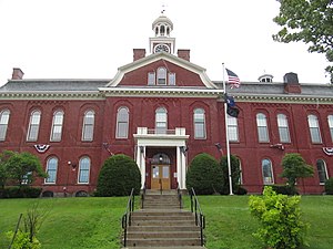
 Aroostook County Courthouse | |
 Location within the U.S. state of Maine | |
 Maine's location within the U.S. | |
| Coordinates: 46°39′N 68°35′W / 46.65°N 68.59°W | |
| Country | |
| State | |
| Founded | May 1, 1839 |
| Named for | Miꞌkmaq word meaning "beautiful water"[1][2] |
| Seat | Houlton |
| Largest city | Presque Isle |
| Area | |
| • Total | 6,828 sq mi (17,680 km2) |
| • Land | 6,671 sq mi (17,280 km2) |
| • Water | 156 sq mi (400 km2) 2.3% |
| Population (2020) | |
| • Total | 67,105 |
| • Density | 9.8/sq mi (3.8/km2) |
| Time zone | UTC−5 (Eastern) |
| • Summer (DST) | UTC−4 (EDT) |
| Congressional district | 2nd |
| Website | www |
Aroostook County (/əˈruːstək/ ə-ROO-stək; French: Comté d'Aroostook) is a county in the U.S. state of Maine along the Canada–United States border. As of the 2020 census, the population was 67,105.[3] The county seat is Houlton,[4] with offices in Caribou and Fort Kent.[5]
Known in Maine as "The County",[6][7] it is the largest county in Maine by total area, the second-largest in the United States east of the Mississippi River by total area,[8][9][6] behind St. Louis County, Minnesota) and the 31st-largest county in the entire contiguous U.S. With over 6,800 square miles (18,000 km2) of land, it is larger than three of the smaller U.S. states. It is Maine's northernmost county; the state's northernmost village, Estcourt Station, is also the northernmost community in the New England region and in the contiguous United States east of the Great Lakes.
Aroostook County is known for its potato cultivation, and it is an emerging hub for wind power. Historically, Acadian culture and heritage is well-represented in the county. In the Saint John Valley (northern Aroostook county), which borders Madawaska County, New Brunswick, many of the residents are bilingual in English and Acadian French. Elsewhere in Maine, New England French is the predominant form of French spoken. As well, the original inhabitants of the area, the Wolastoqiyik still remain in their country (Wolastokuk) as the Houlton Band of Metaksonekiyak Wolastoqewiyik.
Aroostook County forms the entirety of the Presque Isle media market, according to Nielsen Media Research.
- ^ "Aroostook | county, Maine, United States".
- ^ "Aroostook County Government". Aroostook.me.us. January 5, 2012. Archived from the original on May 22, 2013. Retrieved May 11, 2013.
- ^ "Census - Geography Profile: Aroostook County, Maine". United States Census Bureau. Retrieved November 21, 2021.
- ^ "Find a County". National Association of Counties. Archived from the original on May 31, 2011. Retrieved June 7, 2011.
- ^ "Home". aroostook.me.us. Retrieved August 23, 2019.
- ^ a b "Aroostook County - Undiscovered Maine - University of Maine". Undiscovered Maine. Retrieved January 17, 2022.
- ^ "Aroostook County, Maine - Visit Maine - Visit Maine". visitmaine.com. Retrieved January 17, 2022.
- ^ Papantonis, Nicholas (April 20, 2020). "No, Horry County is not the largest county east of the Mississippi". WPDE. Retrieved January 17, 2022.
- ^ "Sussex County is large, but not the largest in the east". Cape Gazette. Retrieved January 17, 2022.
© MMXXIII Rich X Search. We shall prevail. All rights reserved. Rich X Search

