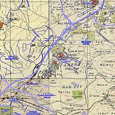
Artuf
عرتوف | |
|---|---|
 Artuf July 1948. Shortly before it was destroyed by the Harel Brigade | |
| Etymology: Artuf; personal name[1] | |
A series of historical maps of the area around Artuf (click the buttons) | |
Location within Mandatory Palestine | |
| Coordinates: 31°46′03″N 35°00′05″E / 31.76750°N 35.00139°E | |
| Palestine grid | 150/130 |
| Geopolitical entity | Mandatory Palestine |
| Subdistrict | Jerusalem |
| Date of depopulation | 18 July 1948[3] |
| Area | |
| • Total | 403 dunams (40.3 ha or 100 acres) |
| Population (1945) | |
| • Total | 350[2] |
| Cause(s) of depopulation | Military assault by Yishuv forces |
| Current Localities | Naham[4] |
Artuf (Arabic: عرتوف) was a Palestinian village in the Jerusalem foothills depopulated in 1948. It was situated 21.5 kilometers (13.4 mi) west of Jerusalem on a high plateau, surrounded by plains on the south, east, and west. The village was on a secondary road that linked it to the main road to Jerusalem.[5]
- ^ Palmer, 1881, p. 284
- ^ a b Cite error: The named reference
Hadawi56was invoked but never defined (see the help page). - ^ Morris, 2004, p. xx, village 334. Also gives cause of depopulation
- ^ Cite error: The named reference
Khalidi269was invoked but never defined (see the help page). - ^ Khalidi, 1992, p.268
© MMXXIII Rich X Search. We shall prevail. All rights reserved. Rich X Search


