Back مقاطعة أشتابولا (أوهايو) Arabic آشتابولا بؤلگهسی، اوهایو AZB Ashtabula County, Ohio BAR Аштъбюла (окръг, Охайо) Bulgarian অ্যাশটাবুলা কাউন্টি, ওহাইও BPY Ashtabula Gông (Ohio) CDO Ashtabula County CEB Ashtabula County, Ohio Welsh Ashtabula County Danish Ashtabula County German
Ashtabula County | |
|---|---|
 Ashtabula County Courthouse | |
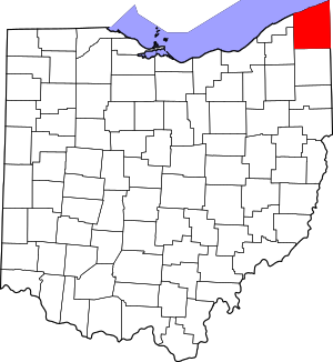
 Location within the U.S. state of Ohio | |
 Ohio's location within the U.S. | |
| Coordinates: 41°53′N 80°46′W / 41.89°N 80.76°W | |
| Country | |
| State | |
| Founded | May 1, 1811 |
| Named for | Lenape ashtepihële 'always enough fish to go around' |
| Seat | Jefferson |
| Largest city | Ashtabula |
| Area | |
| • Total | 1,368 sq mi (3,540 km2) |
| • Land | 702 sq mi (1,820 km2) |
| • Water | 666 sq mi (1,720 km2) 49% |
| Population (2020) | |
| • Total | 97,574 |
| • Density | 71/sq mi (27/km2) |
| Time zone | UTC−5 (Eastern) |
| • Summer (DST) | UTC−4 (EDT) |
| Congressional district | 14th |
| Website | www |
Ashtabula County (/ˌæʃtəˈbjuːlə/ ASH-tə-BYU-lə) is the northeasternmost county in the U.S. state of Ohio. As of the 2020 census, the population was 97,574.[1] The county seat is Jefferson, while its largest city is Ashtabula.[2] The county was created in 1808 and later organized in 1811.[3] The name[4] Ashtabula derives from the Lenape language phrase ashte-pihële, which translates to 'always enough (fish) to go around, to be given away'[5] and is a contraction of apchi ('always')[6] + tepi ('enough') + hële (verb of motion).[7] Ashtabula County is part of the Cleveland, OH Metropolitan Statistical Area.
The county is best known for having nineteen covered bridges within the county limits, including both the longest and the shortest covered bridges in the United States. Grapes are a popular crop and there are several award-winning wineries in the region due to the favorable microclimate from the nearby lake.[8] During the winter, Ashtabula County (along with neighboring Geauga and Lake counties, as well as Crawford and Erie counties in neighboring Pennsylvania) receives frequent lake-effect snow and is part of the Southeastern Lake Erie Snowbelt.
- ^ 2020 census
- ^ "Find a County". National Association of Counties. Archived from the original on May 31, 2011. Retrieved June 7, 2011.
- ^ "Ohio: Individual County Chronologies". Ohio Atlas of Historical County Boundaries. The Newberry Library. 2007. Archived from the original on April 6, 2016. Retrieved February 12, 2015.
- ^ Cross, Tom (2008). Fishing Ohio: An Angler's Guide to Over 200 Fishing Spots in the Buckeye State. Lyons Press. p. 112. ISBN 978-0-7627-4326-1.
- ^ Mahr, August C. (November 1959). "Practical Reasons for Algonkian Indian Stream and Place Names". Ohio Journal of Science. 59 (6): 365–375. hdl:1811/4658. ISSN 0030-0950. Retrieved August 3, 2016.
- ^ "apchi". Lenape Talking Dictionary. Archived from the original on March 4, 2016. Retrieved August 3, 2016.
- ^ "tèpihële". Lenape Talking Dictionary. Archived from the original on March 4, 2016. Retrieved August 3, 2016.
- ^ "Ferrante Winery brings home the gold". The Ashtabula Wave. Archived from the original on April 14, 2016. Retrieved April 1, 2016.
© MMXXIII Rich X Search. We shall prevail. All rights reserved. Rich X Search

