Back مقاطعة أتكينسون (جورجيا) Arabic Atkinson County, Georgia BAR Аткинсън (окръг, Джорджия) Bulgarian এটকিনশন কাউন্টি, জর্জিয়া BPY Atkinson Gông (Georgia) CDO Аткинсон (гуо, Джорджи) CE Atkinson County CEB Atkinson County Czech Atkinson County, Georgia Welsh Atkinson County German
Atkinson County | |
|---|---|
 Atkinson County Courthouse in Pearson | |
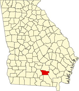
 Location within the U.S. state of Georgia | |
 Georgia's location within the U.S. | |
| Coordinates: 31°17′N 82°52′W / 31.29°N 82.87°W | |
| Country | |
| State | |
| Founded | August 15, 1917 |
| Named for | William Yates Atkinson |
| Seat | Pearson |
| Largest city | Pearson |
| Area | |
| • Total | 345 sq mi (890 km2) |
| • Land | 339 sq mi (880 km2) |
| • Water | 5.2 sq mi (13 km2) 1.5% |
| Population (2020) | |
| • Total | 8,286 |
| • Density | 24/sq mi (9/km2) |
| Time zone | UTC−5 (Eastern) |
| • Summer (DST) | UTC−4 (EDT) |
| Congressional district | 8th |
| Website | atkinsoncounty |
Atkinson County is a county located in the southeastern region of the U.S. state of Georgia. As of the 2020 census, the county's population was 8,286.[1] The county seat is Pearson.[2] The county was formed in 1917 from parts of Coffee and Clinch counties. It is named for William Yates Atkinson, Democratic governor of Georgia from 1894 to 1898.[3] In 2003, it had the highest illiteracy rate of any U.S. county at 36%.[4]
- ^ "Census - Geography Profile: Atkinson County, Georgia". United States Census Bureau. Retrieved December 26, 2022.
- ^ "Find a County". National Association of Counties. Archived from the original on May 31, 2011. Retrieved June 7, 2011.
- ^ Krakow, Kenneth K. (1975). Georgia Place-Names: Their History and Origins (PDF). Macon, GA: Winship Press. p. 8. ISBN 0-915430-00-2. Archived (PDF) from the original on April 14, 2004.
- ^ "State and County Literacy Estimates - State Estimates". nces.ed.gov. Retrieved March 18, 2018.
© MMXXIII Rich X Search. We shall prevail. All rights reserved. Rich X Search