Back Обанж Bulgarian Aubange Breton Aubange Catalan Aubange (parokya) CEB Aubange German Ωμπάνζ Greek Aubange Esperanto Aubange Spanish Aubange Estonian Aubange Basque
Aubange
Éibeng (Luxembourgish) Ibingen (German) | |
|---|---|
City and municipality | |
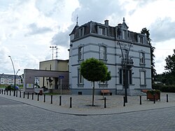
 The townhall in Athus | |
| Coordinates: 49°34′N 05°48.3′E / 49.567°N 5.8050°E | |
| Country | |
| Community | French Community |
| Region | Wallonia |
| Province | Luxembourg |
| Arrondissement | Arlon |
| Government | |
| • Mayor | Jean-Paul Dondelinger (cdH) |
| • Governing party/ies | CDH.com - Intérêt Général (IG) |
| Area | |
| • Total | 46.11 km2 (17.80 sq mi) |
| Population (2018-01-01)[1] | |
| • Total | 16,927 |
| • Density | 370/km2 (950/sq mi) |
| Postal codes | 6790-6792 |
| NIS code | 81004 |
| Area codes | 063 |
| Website | www.aubange.be |
Aubange (French pronunciation: [obɑ̃ʒ] ; German: Ibingen; Luxembourgish: Éibeng; Walloon: Åbindje) is a city and municipality of Wallonia located in the province of Luxembourg, Belgium.
On 1 January 2012 the municipality, which covers 45.6 km2, had 16,042 inhabitants, giving a population density of 330.9 inhabitants per km2. It is the third municipality of the Province of Luxembourg regarding the number of inhabitants but it is also among the smallest ones in terms of area.
The municipality is French-speaking but most of which falls within the Luxembourgish-speaking Arelerland, adjoins the tripoint where the borders of Belgium, the Grand Duchy of Luxembourg, and France meet.
The municipality consists of the following districts: Athus, Aubange, Halanzy, and Rachecourt.
- ^ "Wettelijke Bevolking per gemeente op 1 januari 2018". Statbel. Retrieved 9 March 2019.
© MMXXIII Rich X Search. We shall prevail. All rights reserved. Rich X Search


