Back اڤالدسنيس ARZ Avaldsnes German Avaldsnes Spanish Ögvaldsnes Icelandic Avaldsnes JV Avaldsnes Malay Avaldsnes Dutch Avaldsnes NN Avaldsnes (tettsted) NB Avaldsnes Swedish
Avaldsnes | |
|---|---|
Village | |
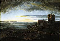
 View of St. Olav’s Church at Avaldsnes Johan Christian Dahl (1820) | |
Location in Rogaland county | |
| Coordinates: 59°21′16″N 05°16′37″E / 59.35444°N 5.27694°E | |
| Country | Norway |
| Region | Western Norway |
| County | Rogaland |
| District | Haugaland |
| Municipality | Karmøy |
| Area | |
| • Total | 3.13 km2 (1.21 sq mi) |
| Elevation | 19 m (62 ft) |
| Population (2019)[1] | |
| • Total | 2,890 |
| • Density | 923/km2 (2,390/sq mi) |
| Time zone | UTC+01:00 (CET) |
| • Summer (DST) | UTC+02:00 (CEST) |
| Post Code | 4262 Avaldsnes |
Avaldsnes is a village in Karmøy municipality in Rogaland county, Norway. The village is located on the northeastern part of the island of Karmøy, along the Karmsundet strait, just south of the town of Haugesund. The village was an ancient centre of power on the west coast of Norway and is the site of one of Norway's more important areas of cultural history. The trading port of Notow and the Avaldsnes Church are two notable historic sites in Avaldsnes.
The village was the administrative centre of the old municipality of Avaldsnes which existed from 1838 until 1965. The 3.13-square-kilometre (770-acre) village has a population (2019) of 2,890 and a population density of 923 inhabitants per square kilometre (2,390/sq mi).[1]
Avaldsnes has been described as "Norway's oldest capital" because it was the primary residency of Harald Fairhair who unified Norway into one kingdom.[3]
- ^ a b c Statistisk sentralbyrå (1 January 2019). "Urban settlements. Population and area, by municipality".
- ^ "Avaldsnes, Karmøy (Rogaland)" (in Norwegian). yr.no. Retrieved 2015-10-30.
- ^ Price, T. Douglas (2015-06-12). Ancient Scandinavia: An Archaeological History from the First Humans to the Vikings. Oxford University Press. p. 335. ISBN 978-0-19-023199-6.
© MMXXIII Rich X Search. We shall prevail. All rights reserved. Rich X Search

