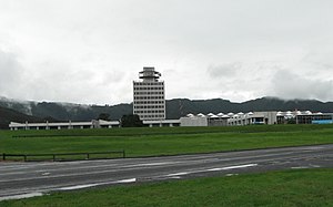
Avalon | |
|---|---|
 Avalon Studios | |
 | |
| Coordinates: 41°11′35″S 174°56′25″E / 41.1931°S 174.9404°E | |
| Country | New Zealand |
| City | Lower Hutt |
| Local authority | Hutt City Council |
| Electoral ward | Central |
| Area | |
| • Land | 203 ha (502 acres) |
| Population (June 2023)[2] | |
| • Total | 5,440 |
| Taitā | ||
| Belmont |
|
Wingate |
| Boulcott | Epuni | Naenae |

Avalon is a suburb of Lower Hutt, in the Wellington Region of New Zealand. It was formed as a private residential development in the 1970s on land formerly occupied by market-gardens on the left (eastern) bank of the Hutt River.[3] It features mostly California-inspired designed houses, often split-level, with 3 or 4 bedrooms. It also features Avalon Park, one of the biggest playgrounds in Lower Hutt.[4][5]
The Hutt City Council formally defines Avalon as the area bounded by Percy Cameron Street and the Wingate Overbridge in the north, the Hutt Valley rail line in the east, Fairway Drive and Daysh Street in the south, and the Hutt River in the west.[6]
- ^ Cite error: The named reference
Areawas invoked but never defined (see the help page). - ^ "Population estimate tables - NZ.Stat". Statistics New Zealand. Retrieved 25 October 2023.
- ^ Taonga, New Zealand Ministry for Culture and Heritage Te Manatu. "Hutt Valley – central and west". teara.govt.nz. Retrieved 11 December 2021.
- ^ "Avalon Park". www.huttvalleynz.com. Retrieved 11 December 2021.
- ^ "Avalon Park - Places New Zealand". places.nz. Retrieved 11 December 2021.
- ^ "Hutt City Wards and Suburbs" (PDF). Hutt City Council. Archived from the original (PDF) on 9 February 2013. Retrieved 25 August 2013.
© MMXXIII Rich X Search. We shall prevail. All rights reserved. Rich X Search
