Back نهر افون (نهر فى كندا) ARZ Avon River (suba sa Kanada, Nova Scotia) CEB Avon River (Bay of Fundy) German Avon River (vattendrag i Kanada, Nova Scotia) Swedish
| Avon River | |
|---|---|
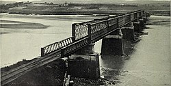
 19th-century photograph of the Dominion Atlantic Railway bridge at Windsor | |
| Location | |
| Country | Canada |
| Province | Nova Scotia |
| Physical characteristics | |
| Mouth | |
• location | Minas Basin |
• elevation | sea level |
| Length | 64 km (40 mi) |
| Basin size | 1,306 km2 (504 sq mi) |
The Avon River is a small river in central Nova Scotia, Canada.
A northerly flowing river, the Avon River's flow rises at an elevation of 145 metres (475 ft.) at Card and Bag Lakes on the South Mountain, a distance of approximately 29 kilometres (18 miles) southwest of the town of Windsor. Its meander length is 64 km (40 mi).[1] At Windsor Forks, the West Branch Avon River (the main tributary) and the Southwest Branch Avon add their flow to the Avon. The West Branch Avon River rises at an elevation of 175 metres (574 ft.) at Black River Lake. Both the flows of the Avon and the West Branch have been impeded by hydropower developments in the early twentieth century. Near the rural community of Martock, the river enters a broad glacial river valley forming a ria[2] where it becomes tidal, creating an estuary for its remaining route to the Minas Basin at Kempt Shore,[3][circular reference] several kilometres downriver from the town of Hantsport. Another tributary, the St. Croix River joins just below Windsor creating a total watershed of 1,306 square kilometres.[4]
Rivers flowing into the Avon include the Halfway, Herbert, Cogmagun, Kennetcook and St. Croix.
The Avon River is evident on many very early maps of the region and by 1686 is shown, along with its drainage basin, on Jean-Baptiste-Louis Franquelin's map in great detail.
- ^ North American Gazetteer Archived January 6, 2006, at the Wayback Machine
- ^ Schematic drawing and description Archived September 27, 2006, at the Wayback Machine
- ^ "Kempt Shore, Nova Scotia".
- ^ Natural History of Nova Scotia, Volume 1, Chapter T8 "Freshwater Hydrology", Nova Scotia Museum (1996) p.152
© MMXXIII Rich X Search. We shall prevail. All rights reserved. Rich X Search