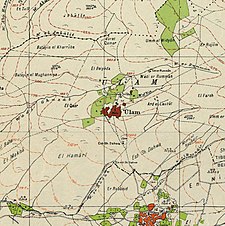
Awlam
عولم 'Ulam | |
|---|---|
| Etymology: possibly from the Arabic form of “a full well”[1] | |
A series of historical maps of the area around Awlam (click the buttons) | |
Location within Mandatory Palestine | |
| Coordinates: 32°39′59″N 35°29′57″E / 32.66639°N 35.49917°E | |
| Palestine grid | 197/230 |
| Geopolitical entity | Mandatory Palestine |
| Subdistrict | Tiberias |
| Date of depopulation | April 6, 1948[4] |
| Area | |
| • Total | 18,546 dunams (18.5 km2 or 7.1 sq mi) |
| Population (1945) | |
| • Total | 720[2][3] |
| Cause(s) of depopulation | Abandonment on Arab orders |
Awlam (Arabic: عولم) was a Palestinian village 15 kilometres (9.3 mi) south of Tiberias situated on the slopes of the westward Wadi Awlam.[5]
In the late Ottoman period it was a ruin, resettled by Algerian migrants under the auspices of the Ottomans.[6]
- ^ Palmer, 1881, p. 159
- ^ Department of Statistics, 1945, p. 12
- ^ Government of Palestine, Department of Statistics. Village Statistics, April, 1945. Quoted in Hadawi, 1970, p. 73
- ^ Morris, 2004, p. xvii, village #107. Also gives cause of depopulation
- ^ Cite error: The named reference
Khalidiwas invoked but never defined (see the help page). - ^ Ahmad Abbasi, Mustafa (2007). "הקהילה האלג'יראית בגליל משלהי השלטון העות'מני עד שנת 1948". אופקים בגיאוגרפיה. 68/9: 61.
© MMXXIII Rich X Search. We shall prevail. All rights reserved. Rich X Search


