Back فال أيلزبري Arabic Айлсбъри Вейл (община) Bulgarian Aylesbury Vale CEB Aylesbury Vale German Aylesbury Vale Spanish الزبری ول Persian Aylesbury Vale French Aylesbury Vale Italian 에일즈베리베일 Korean Aylesbury Vale Dutch
Aylesbury Vale | |
|---|---|
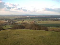
 Part of Aylesbury Vale taken from the top of Coombe Hill, looking towards Aylesbury | |
 Aylesbury Vale shown within Buckinghamshire | |
| Sovereign state | United Kingdom |
| Constituent country | England |
| Region | South East England |
| Ceremonial county | Buckinghamshire |
| Area | |
| • Total | 348.55 sq mi (902.75 km2) |
| Population (mid-2018) | |
| • Total | 199,448 |
| • Density | 570/sq mi (220/km2) |
| • Ethnicity | 92.3% White 3.7% S.Asian 1.5% Black 1.5% Mixed 1.0% Chinese or Other |
| Time zone | UTC0 (GMT) |
| • Summer (DST) | UTC+1 (BST) |
| ONS code | 11UB (ONS) E07000004 (GSS) |
| OS grid reference | SP818138 |
| Website | www |
The Aylesbury Vale (or Vale of Aylesbury) is a geographical region in Buckinghamshire, England, which is bounded by the City of Milton Keynes and West Northamptonshire to the north, Central Bedfordshire and the Borough of Dacorum (Hertfordshire) to the east, the Chiltern Hills to the south and South Oxfordshire to the west. It is named after Aylesbury, the county town of Buckinghamshire. Winslow and Buckingham are among the larger towns in the vale.
The bed of the vale is largely made up of clay that was formed at the end of the ice age.
In the 2011 UK census the population of Aylesbury Vale was 174,900. In the 2001 UK census the population of Aylesbury Vale was 165,748, representing an increase since 1991 of 18,600 people.[1] About half of those live in the county town Aylesbury.
© MMXXIII Rich X Search. We shall prevail. All rights reserved. Rich X Search