Back Azanië Afrikaans አዛኒያ Amharic آزانيا Arabic Azaniya Azerbaijani Azània Catalan Azania German Αζανία Greek Azania Spanish Azania Finnish Azanie French
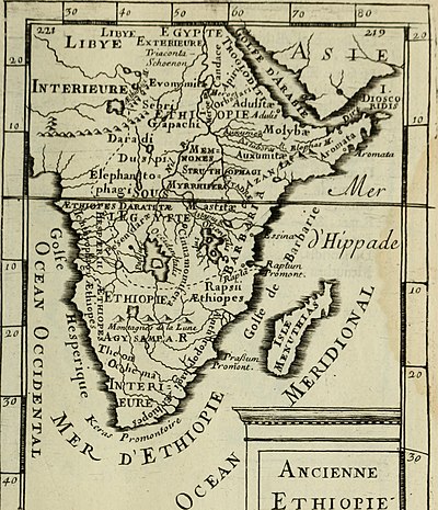
Map of Africa, Description de l'univers (1683); Azania is circled.
Azania (Ancient Greek: Ἀζανία)[1] is a name that has been applied to various parts of southeastern tropical Africa.[2] In the Roman period and perhaps earlier, the toponym has been hypothesised to have referred to a portion of the Southeast Africa coast extending from southern Somalia to the border between Mozambique and South Africa.[3][4] If this is correct, then during classical antiquity Azania was mostly inhabited by Southern Cushitic peoples, whose groups would rule the area until the great Bantu Migration.[5][6]
- ^ Periplus of the Erythraean Sea, 15
- ^ Collins & Pisarevsky (2004). "Amalgamating eastern Gondwana: The evolution of the Circum-Indian Orogens". Earth-Science Reviews. 71 (3): 229–270. Bibcode:2005ESRv...71..229C. doi:10.1016/j.earscirev.2005.02.004.
- ^ Richard Pankhurst, An Introduction to the Economic History of Ethiopia, (Lalibela House: 1961), p.21
- ^ The rise of Azania. Snippet w: David Dube. 1983. p. 17.
- ^ JournalInsert Hilton, John (1993-10). "Peoples of Azania". Electronic Antiquity: Communicating the Classics. 1 (5). ISSN 1320-3606. Check date values in: |date= (help).
- ^ Azania. 1983.
© MMXXIII Rich X Search. We shall prevail. All rights reserved. Rich X Search

