Back بعقلين Arabic بعقلين ARZ Baaqlîne CEB Baaklin German Baakline Spanish بعقلین Persian Baakline French בעקלין HE Baakline Italian Baakleen NN
This article needs additional citations for verification. (August 2014) |
Baakline
بعقلين | |
|---|---|
Town | |
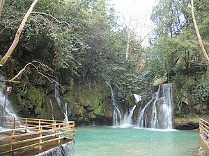
 Blue waterfall of Shallalat Al Zarka | |
| Coordinates: 33°40′47″N 35°33′30″E / 33.67972°N 35.55833°E | |
| Country | |
| Governorate | Mount Lebanon Governorate |
| District | Chouf District |
| Government | |
| Area | |
| • Total | 14 km2 (5 sq mi) |
| Highest elevation | 915 m (3,002 ft) |
| Lowest elevation | 750 m (2,460 ft) |
| Population | |
| • Total | 17,000 |
| • Density | 1,200/km2 (3,100/sq mi) |
| Time zone | UTC+2 (EET) |
| • Summer (DST) | UTC+3 (EEST) |
| Dialing code | +961 |
| Website | www |
Baakleen, Baaqlîne or Baakline (Arabic: بعقلين) is a major Druze town located in Mount Lebanon, Chouf District,[1] 45 kilometers southeast of Beirut. Altitude 850 – 920 meters high, population is 30,000, area 14 square km, number of homes 2,870. Bordering Towns: Deir al-Qamar, Beit ed-Dine, Aynbal, Deir Dourit, Symkanieh, and Jahlieh.
- ^ Ward, Abir (2009). "Women of the Lebanese mountains: A fight for edification". Women's Studies International Forum. 32 (5): 388–394. doi:10.1016/j.wsif.2009.07.004. ISSN 0277-5395.
© MMXXIII Rich X Search. We shall prevail. All rights reserved. Rich X Search
