Back جزر باكان Arabic Batjan Catalan Kepulauan Bacan CEB Bacaninseln German Bakanoj Esperanto Bacan Spanish Bacan Basque Bacan Finnish Bacan French Bacan Galician
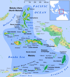
 Topographic map of Bacan and other nearby islands. | |
 | |
| Geography | |
|---|---|
| Location | Southeast Asia |
| Coordinates | 00°36′54″S 127°30′54″E / 0.61500°S 127.51500°E |
| Archipelago | Moluccas (Maluku Islands) |
| Area | 2,792.85 km2 (1,078.33 sq mi) |
| Highest elevation | 2,111 m (6926 ft) |
| Highest point | Buku Sibela |
| Administration | |
| Demographics | |
| Population | 115,612 (mid 2022) |
| Pop. density | 414/km2 (1072/sq mi) |

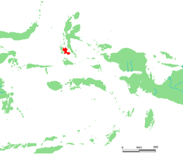
The Bacan Islands, formerly also known as the Bachans, Bachians, and Batchians,[1] are a group of islands in the Moluccas in Indonesia. They are mountainous and forested, lying south of Ternate and southwest of Halmahera. The islands are administered by the South Halmahera Regency of North Maluku Province. They formerly constituted the Sultanate of Bacan.
Bacan (Dutch: Batjan),[2] formerly also known as Bachian[3][2] or Batchian,[4] is the group's largest island. The second and third-largest islands are Kasiruta and Mandioli.[3] Bacan Island in 2020 included about 82,387 people, of which about 10,000 live in the capital Labuha; it is subdivided into seven districts. Kasiruta and Mandioli each have over 11,000 inhabitants, and each is subdivided into two districts. A fourth island, Bacan Lomang, forms a twelfth district within the group. There are dozens of smaller islands in the group, which had a total population of 84,075 at the 2010 Census,[5] but by the 2020 Census had risen to 111,517.[6] The official estimate as at mid 2022 was 115,612.[7]
- ^ "Bacan | island, Indonesia". Encyclopedia Britannica. Archived from the original on 2020-02-18. Retrieved 2020-05-29.
- ^ a b EB (1911), p. 132.
- ^ a b EB (1878).
- ^ Encyclopædia Britannica, 9th ed., Index, p. 39. 1889.
- ^ Cite error: The named reference
Biro Pusat Statistik 2011was invoked but never defined (see the help page). - ^ Badan Pusat Statistik, Jakarta, 2021.
- ^ Badan Pusat Statistik, Jakarta, 2023.
© MMXXIII Rich X Search. We shall prevail. All rights reserved. Rich X Search