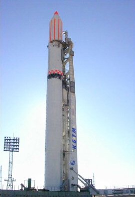
 Badr-B atop a Zenit-2 rocket, before the launch | |
| Mission type | Earth Observation Satellite Earth science |
|---|---|
| Operator | SUPARCO |
| COSPAR ID | 2001-056C |
| SATCAT no. | 27003 |
| Website | www |
| Mission duration | 2 years |
| Spacecraft properties | |
| Manufacturer | SUPARCO Space Innovations Limited Rutherford Laboratory |
| Launch mass | 68.5 kilograms (151 lb) |
| Start of mission | |
| Launch date | 10 December 2001, 17:18:57 UTC |
| Rocket | Zenit-2 |
| Launch site | Baikonur 45/1 |
| Orbital parameters | |
| Reference system | Geocentric |
| Regime | Sun-synchronous |
| Eccentricity | 0.0018975332 |
| Perigee altitude | 986.0 kilometres (612.7 mi) |
| Apogee altitude | 1,014.0 kilometres (630.1 mi) |
| Inclination | 99.7 degrees |
| Period | 105.0 minutes |
| Epoch | 10 December 2001, 12:19:00 UTC[1] |
The Badr-B (Urdu: بدر-۲; also known as Badr-II, meaning Full Moon-2) was the second spacecraft and the first Earth observation satellite launched into Sun-synchronous orbit on 10 December 2001 at 09:15 by SUPARCO — Pakistan's national space agency.[2] Badr-B was a microsatellite, weighing approximately 70 kg, and contained a computerized system to conduct studies on gravity gradients. Badr-B was a research satellite to explore the upper atmosphere and the near space, carrying a large array of instruments for geophysical research.[2]
The Badr-B payload was equipped with several CCD cameras, compact dosimeter, a telemetry system, charge detector and a temperature control unit.[2] It is intended to complete and update the Islamabad Mission Control Center (IMCC) and to test the remote sensing CCD instruments.[2]
- ^ "NASA - NSSDCA - Spacecraft - Trajectory Details". nssdc.gsfc.nasa.gov. Retrieved 2018-05-01.
- ^ a b c d "Badr-B". SUPARCO's Directorate-General for the Public Relations. SUPARCO and the Government of Pakistan. Archived from the original on July 3, 2018. Retrieved February 3, 2018.
© MMXXIII Rich X Search. We shall prevail. All rights reserved. Rich X Search
