Back Riu Bafing Catalan Bafing (suba sa Mali, lat 13,81, long -10,83) CEB Bafing (řeka) Czech Bafing German Río Bafing Spanish Bafingi jõgi Estonian Bafing Finnish Bafing French Río Bafing Galician Bafing Croatian
| Bafing River Rivière Bafing (French) | |
|---|---|
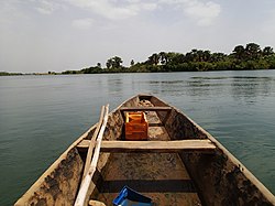
 View of Bafing river from a Bozo Pirogue | |
| Location | |
| Countries | Mali, Guinea |
| Physical characteristics | |
| Source | Fonta Djallon |
| • location | Foranruel, Guinea |
| • coordinates | 10°23′42″N 12°08′06″W / 10.395°N 12.135°W |
| • elevation | 750 m (2,460 ft) |
| Mouth | Senegal River |
• location | Bafoulabé, Mali |
• coordinates | 13°48′47″N 10°49′41″W / 13.813°N 10.828°W |
• elevation | 83 m (272 ft) |
| Length | 350 mi (560 km) |
| Basin features | |
| River system | Senegal River |


The Bafing River (Manding for "black river", French: Rivière Bafing)[1] is the upper course and largest tributary of the Senegal River which runs through Guinea and Mali and is about 350 miles (560 km) long.
- ^ Mohamed Saliou Camara; Thomas O'Toole; Janice E. Baker (7 November 2013). Historical Dictionary of Guinea. Scarecrow Press. p. 38. ISBN 978-0-8108-7969-0.
© MMXXIII Rich X Search. We shall prevail. All rights reserved. Rich X Search
