Back منطقة باجشاور Arabic باجشاور ARZ बागेश्वर जिला Bihari বাগেশ্বর জেলা Bengali/Bangla Bageshwar (distrito sa Indiya) CEB Bageshwar (Distrikt) German Distrito de Bageshwar Spanish Bageshwar barrutia Basque بخش باگیشور Persian Bageshwarin piirikunta Finnish
Bageshwar district | |
|---|---|
Clockwise from top-left: Sarju river at Bageshwar, Panchachuli viewed from Kausani, Pindari Glacier, view from Vijaypur, Baijnath Temple | |
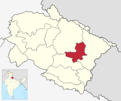
 Location in Uttarakhand | |
| Coordinates: 29°51′N 79°46′E / 29.85°N 79.77°E | |
| Country | |
| State | Uttarakhand |
| Division | Kumaon |
| Headquarters | Bageshwar |
| Government | |
| • District collector | Anuradha Pal, IAS[1] |
| Area | |
| • Total | 2,302 km2 (889 sq mi) |
| Population | |
| • Total | 259,898 |
| • Density | 108/km2 (280/sq mi) |
| Languages | |
| • Official | Hindi |
| • Native | Kumaoni |
| Time zone | UTC+5:30 (IST) |
| Website | bageshwar |
Bageshwar is a district of Uttarakhand state in northern India. The town of Bageshwar is the district headquarters. Prior to its establishment as a district in 1997 it was part of Almora district.[2]
Bageshwar district is in Kumaon, and is bounded on the west and northwest by Chamoli District, on the northeast and east by Pithoragarh District, and on the south by Almora District.
As of 2011 it is the third least populous district of Uttarakhand (out of 13), after Rudraprayag and Champawat.[3]
- ^ "सीमांत जिले पिथौरागढ़ में पहली बार महिला जिलाधिकारी तैनात, बागेश्वर में भी महिला डीएम, देखें किसे मिली कमान". Dainik Jagran (in Hindi). Archived from the original on 31 October 2022. Retrieved 29 October 2022.
- ^ DISTRICT CENSUS HANDBOOK - BAGESHWAR Archived 23 June 2017 at the Wayback Machine
- ^ "District Census 2011". Census2011.co.in. 2011. Archived from the original on 11 June 2011. Retrieved 30 September 2011.
© MMXXIII Rich X Search. We shall prevail. All rights reserved. Rich X Search


