Back مقاطعة بيتادي Arabic बैतडी जिला AWA बैतडी जिला Bihari বৈতডী জেলা Bengali/Bangla বৈতডী BPY Baitadi District Danish Baitadi German बैतडी जिल्ला DTY Baitadin piirikunta Finnish District de Baitadi French
Baitadi District
बैतडी | |
|---|---|
 Tripurasundari temple, Baitadi | |
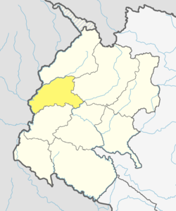
 Location of Baitadi District | |
| Country | |
| Province | Sudurpashchim Province |
| Established | pre 1962 |
| Admin HQ. | Dasharathchand |
| Government | |
| • Type | Coordination committee |
| • Body | DCC, Baitadi |
| Area | |
| • Total | 1,519 km2 (586 sq mi) |
| Population (2011)[1] | |
| • Total | 250,898 |
| • Density | 170/km2 (430/sq mi) |
| Time zone | UTC+05:45 (NPT) |
| Telephone Code | 095 |
| Main Language(s) | Baitadeli |
Baitadi District (Nepali: बैतडी जिल्ला ), historical name “Bairath” (बैराथ)[citation needed], a part of Sudurpashchim Province, is one of the 77 districts of Nepal. It is a Hill district. Baitadi, with Dasharathchand as its headquarters, covers an area of 1,519 km2 (586 sq mi) and has a population of 250,898 according to the census (2011).[1] The Baitadi district entails 56 village development councils (VDCs) and two municipality in the past. Now, by federal policy there are 10 local units; 4 Municipalities (Dashrath Chand, Patan, Melauli and Purchudi) and 6 Rural Municipalities ( Surnaya, Sigas, Shivnath, Pancheshwor, Dogada Kedar and Dilasaini). Baitadi falls into the farthest western regional district of Nepal touching Jhulaghat, India, Nepal's neighboring country, to its border.
- ^ a b "National Population and Housing Census 2011(National Report)" (PDF). Central Bureau of Statistics. Government of Nepal. November 2012. Archived from the original (PDF) on 2013-04-18. Retrieved 20 June 2015.
© MMXXIII Rich X Search. We shall prevail. All rights reserved. Rich X Search