Back مقاطعة باجورا Arabic बाजुरा जिला AWA बाजुरा जिला Bihari বাজুরা জেলা Bengali/Bangla বাজুরা BPY Bājura CEB Bajura Czech Bajura District Danish Bajura German बाजुरा जिल्ला DTY
Bajura District
बाजुरा | |
|---|---|
 | |
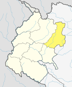
 Location of Bajura District | |
| Coordinates: 29°26′49″N 81°29′12″E / 29.44694°N 81.48667°E | |
| Country | |
| Province | Sudurpashchim Province |
| Admin HQ. | Martadi (today part of Badimalika municipality) |
| Government | |
| • Type | Coordination committee |
| • Body | DCC, Bajura |
| Area | |
| • Total | 2,188 km2 (845 sq mi) |
| Elevation | 6,400 m (21,000 ft) |
| Population (2011)[1] | |
| • Total | 134,912 |
| • Density | 62/km2 (160/sq mi) |
| Time zone | UTC+05:45 (NPT) |
| Postal Codes | 10600 |
| Telephone Code | 097 |
| Main Language(s) | Nepali |
| Website | www |
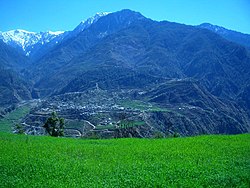
Bajura District (Nepali: बाजुरा जिल्ला ), a part of Sudurpashchim Province, is one of the seventy-seven districts of Nepal. The district, with Martadi (today part of Badimalika municipality) as its district headquarters, covers an area of 2,188 km2 (845 sq mi) and had a population of 108,781 in 2001[2] and 134,912 in 2011.[1]
The annual rainfall is about 13,433 mm and temperatures vary from 0 °C to 40 °C. The livelihood of more than 80% of the district population depends on agriculture farming, mainly small scale livestock. Due to low level of agricultural production, the majority of the households face acute food shortages for a large part of the year. According to the National Census 2011, the total population of the district is 134,912 comprising 69,106 female (51%) and 65,806 male (49%) residing in 24,908 households. Bajura district has an average population density of around 62 people per square km. The average family size is 5.4. Life expectancy of the people is 58 years. The average literacy rate is about 32%. Bajura district has a multi ethnic composition with Chhetri, Kami, Thakuri, Brahman, Damai, SarkI and Sanyashi (Giri and Puri). The common language is Nepali (96%) followed by Bhote Sherpa (0.46%) and Tamang (0.42%).[citation needed] Although accessibility to Bajura is very poor, this is improving rapidly. The Government strategy is mainly focused on the connection of VDC headquarters with all-weather motor able roads to SRN or District headquarters. Moreover, the DDC body of Bajura district has given higher priority on rural roads.[citation needed]
- ^ a b "National Population and Housing Census 2011(National Report)" (PDF). Central Bureau of Statistics. Government of Nepal. November 2012. Archived from the original (PDF) on 18 April 2013. Retrieved 20 June 2015.
- ^ "Nepal Census 2001". Nepal's Village Development Committees. Digital Himalaya. Archived from the original on 12 October 2008. Retrieved 12 December 2008.
© MMXXIII Rich X Search. We shall prevail. All rights reserved. Rich X Search