This article needs additional citations for verification. (November 2013) |
Balingasa
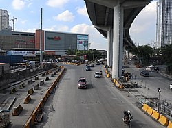
Balintawak Cloverleaf | |
|---|---|
Barangay | |
 | |
 Map of Quezon City showing Balingasa | |
 | |
| Coordinates: 14°39′2″N 121°0′5″E / 14.65056°N 121.00139°E | |
| Country | Philippines |
| Region | National Capital Region |
| City | Quezon City |
| District | 1st District of Quezon City |
| Government | |
| • Type | Barangay |
| • Barangay Captain | Ma. Teresa Montalbo[1] |
| Area | |
| • Total | 0.8111 km2 (0.3132 sq mi) |
| Population (2020)[3] | |
| • Total | 19,260 |
| • Density | 24,000/km2 (62,000/sq mi) |
| Time zone | UTC+8 (PST) |
| Postal Code | 1105 |
| Area code | 2 |
| PSGC | 137404013 |
| Website | |
Balingasa, commonly known as Balintawak and Cloverleaf, is an administrative division in eastern Metro Manila, the Philippines. It is an urban barangay located in Quezon City, at the city's western boundary with Caloocan.
The barangay's borders are defined by EDSA and barangay Unang Sigaw to the north, barangays Pag-Ibig Sa Nayon and Damar to the south, barangay Manresa and Gregorio Araneta Avenue in the southeast, and barangay Apolonio Samson in the east.[2]
- ^ "Quezon City Barangay Officials". Quezon City Government. 2021-01-08. Retrieved 2022-05-22.
- ^ a b History of QC Barangays: Journey to Early Beginnings of Quezon City Barangays. Vol. 1. Quezon City: Quezon City Public Library. 2019.
- ^ Census of Population (2020). Table B - Population and Annual Growth Rates by Province, City, and Municipality - By Region. Philippine Statistics Authority. Retrieved 8 July 2021.
© MMXXIII Rich X Search. We shall prevail. All rights reserved. Rich X Search
