Barqa
برقة Burqa | |
|---|---|
![Maqam (shrine) of Neby Burk, in 1898[1]](http://upload.wikimedia.org/wikipedia/commons/thumb/9/91/Neby_Berak_1898_%28Gautier%29.jpg/250px-Neby_Berak_1898_%28Gautier%29.jpg) Maqam (shrine) of Neby Burk, in 1898[1] | |
| Etymology: sandy ground covered with flint[2] | |
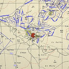
A series of historical maps of the area around Barqa, Gaza (click the buttons) | |
Location within Mandatory Palestine | |
| Coordinates: 31°46′35″N 34°42′5″E / 31.77639°N 34.70139°E | |
| Palestine grid | 121/131 |
| Geopolitical entity | Mandatory Palestine |
| Subdistrict | Gaza |
| Date of depopulation | May 13, 1948[5] |
| Area | |
| • Total | 5,206 dunams (5.206 km2 or 2.010 sq mi) |
| Population (1945) | |
| • Total | 890[3][4] |
| Cause(s) of depopulation | Military assault by Yishuv forces |
| Current Localities | Gan Yavne |
Barqa (Arabic: برقة) was a Palestinian Arab village located 37 km north of Gaza near the modern-day Israeli city of Ashdod. It was referred to as Barka by the Greeks and Bareca by the Romans during their rule over the ancient Philistine city. In 1945, the village had a population of 890 and total land area of 5,206 dunums.
It was occupied and depopulated on May 13, 1948 during Operation Barak, a Yishuv offensive in southern Palestine just prior to the outbreak of the 1948 Arab-Israeli War. The ruins of the village were later incorporated into the Israeli town of Gan Yavne.
© MMXXIII Rich X Search. We shall prevail. All rights reserved. Rich X Search


