Back Barrett Township, Monroe County, Pennsylvania Welsh Municipio de Barrett (Pensilvania) Spanish Барретт Тауншип (округ Монро, Пенсільванія) Ukrainian Xã Barrett, Quận Monroe, Pennsylvania Vietnamese
Barrett Township, Pennsylvania | |
|---|---|
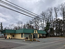
 Barrett Township Municipal Building | |
 | |
 Location of Pennsylvania in the United States | |
| Coordinates: 41°13′00″N 75°11′59″W / 41.21667°N 75.19972°W | |
| Country | United States |
| State | Pennsylvania |
| County | Monroe |
| Area | |
| • Total | 52.99 sq mi (137.24 km2) |
| • Land | 52.38 sq mi (135.66 km2) |
| • Water | 0.61 sq mi (1.59 km2) |
| Elevation | 1,407 ft (429 m) |
| Population | |
| • Total | 4,053 |
| • Estimate (2021)[2] | 4,061 |
| • Density | 77.38/sq mi (29.88/km2) |
| Time zone | UTC-5 (EST) |
| • Summer (DST) | UTC-4 (EDT) |
| Area code | 570 |
| FIPS code | 42-089-04320 |
| Website | http://www.barretttownship.com |
Barrett Township is a township in Monroe County, Pennsylvania, United States. The population was 4,053 at the 2020 census.[3] Two Poconos resort communities, Buck Hill Falls and Skytop, are located within the township. It is located 38 miles from Scranton and 48 miles from Wilkes-Barre. There is one privately owned, public-use airport in Barrett Township, called the Flying Dollar Airport.
- ^ "2016 U.S. Gazetteer Files". United States Census Bureau. Retrieved August 14, 2017.
- ^ a b Bureau, US Census. "City and Town Population Totals: 2020—2021". Census.gov. US Census Bureau. Retrieved August 6, 2022.
- ^ 2020 United States Census Barrett township, Pennsylvania https://www.census.gov/search-results.html?searchType=web&cssp=SERP&q=Barrett%20township,%20Monroe%20County,%20Pennsylvania
© MMXXIII Rich X Search. We shall prevail. All rights reserved. Rich X Search