Back ولاية البصرة Arabic Bəsrə vilayəti Azerbaijani ویلایەتی بەسڕە CKB Vilâyet Basra German Valiato de Basora Spanish Basra vilajett Estonian ولایت بصره Persian Vilayet de Bassora French וילאייט בצרה HE Vilayet di Basra Italian
Vilayet of Basra | |||||||||
|---|---|---|---|---|---|---|---|---|---|
| 1875–1880 1884–1918 | |||||||||
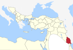
 The Basra Vilayet in 1900 | |||||||||
| Capital | Basra[1] | ||||||||
| Governor | |||||||||
• 1875-1877 | Nasir Pasha | ||||||||
• 1916-1918 | Khalil Pasha | ||||||||
| History | |||||||||
• Established | 1884 | ||||||||
| 1918 | |||||||||
| Area | |||||||||
| 1900[2] | 42,690 km2 (16,480 sq mi) | ||||||||
| Population | |||||||||
• 1900[2] | 500,000 | ||||||||
| |||||||||
| Today part of | Iraq Kuwait Qatar Saudi Arabia | ||||||||
The Basra Vilayet (Arabic: ولاية البصرة, Ottoman Turkish: ولايت بصره, romanized: Vilâyet-i Basra) was a first-level administrative division (vilayet) of the Ottoman Empire. It historically covered an area stretching from Nasiriyah and Amarah in the north to Kuwait in the south.[1] To the south and the west, there was theoretically no border at all, yet no areas beyond Qatar in the south and the Najd Sanjak in the west were later on included in the administrative system.[3]
At the beginning of the 20th century it reportedly had an area of 16,482 square miles (42,690 km2), while the preliminary results of the first Ottoman census of 1885 (published in 1908) gave the population as 200,000.[2] The accuracy of the population figures ranges from "approximate" to "merely conjectural" depending on the region from which they were gathered.[2]
The capital of the vilayet, Basra, was an important military centre, with a permanent garrison of 400 to 500 men, and was home to the Ottoman Navy in the Persian Gulf.[1]
- ^ a b c Reidar Visser (2005). Basra, the Failed Gulf State: Separatism And Nationalism in Southern Iraq. LIT Verlag Münster. p. 19. ISBN 978-3-8258-8799-5. Retrieved 8 June 2013.
- ^ a b c Asia by A. H. Keane, page 460
- ^ Reidar Visser (2005). Basra, the Failed Gulf State: Separatism And Nationalism in Southern Iraq. LIT Verlag Münster. pp. 18, 179. ISBN 978-3-8258-8799-5. Retrieved 2013-06-08.
© MMXXIII Rich X Search. We shall prevail. All rights reserved. Rich X Search

