Bayfield | |
|---|---|
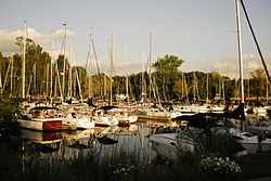
 Marina in Bayfield | |
| Coordinates: 43°33′36″N 81°41′57″W / 43.56000°N 81.69917°W[1] | |
| Country | Canada |
| Province | Ontario |
| County | Huron County |
| Municipality | Bluewater |
| Founded | 1832 |
| Founded by | Carel Lodewijk |
| Time zone | UTC-5 (Eastern Time Zone) |
| • Summer (DST) | UTC-4 (Eastern Time Zone) |
| Area codes | 519, 226, 548 |
Bayfield is a community in the municipality of Bluewater, Huron County in southwestern Ontario, Canada[1][2][3][4][5] with a 2016 population of 1,112.[6] Bluewater Municipality includes Bayfield, Bruce field, Dashwood, Hensall, Varna, and Zurich[7] This municipality is made up of 92.8% English speaking people, 6.3% of other language speaking people and 0.9% of French speaking people as of 2016. In addition to this the majority of Bayfield's population is made up of Canadians, creating 88.2% of the population in the year 2016.[8] It is on the eastern shore of Lake Huron at the mouth of Bayfield River.[4][5] Bayfield is a popular tourist destination. Visitors enjoy the historic Main Street with its many well-preserved old buildings,[9] including the Little Inn which has served travelers since the 1800s, initially as a stagecoach stop.[10] Main Street is lined with boutique shops, art galleries and fine dining restaurants. The nearby marina and public beaches draw crowds in the summer months.
- ^ a b "Bayfield". Geographical Names Data Base. Natural Resources Canada. Retrieved 2020-05-31.
- ^ "Toporama (on-line map and search)". Atlas of Canada. Natural Resources Canada. Retrieved 2020-05-31.
- ^ Restructured municipalities - Ontario map #6 (Map). Restructuring Maps of Ontario. Ontario Ministry of Municipal Affairs and Housing. 2006. Archived from the original on 2021-02-24. Retrieved 2020-05-31.
- ^ a b "Ontario Geonames GIS (on-line map and search)". Ontario Ministry of Natural Resources and Forestry. 2014. Retrieved 2020-05-31.
- ^ a b Map 2 (PDF) (Map). 1 : 700,000. Official road map of Ontario. Ministry of Transportation of Ontario. 2018-01-01. Retrieved 2020-05-31.
- ^ Census Profile, 2016, Statistics Canada
- ^ "Municipality of Bluewater". Municipality of Bluewater. Archived from the original on 2016-07-08. Retrieved 24 February 2021.
- ^ Brinkhoff, Thomas (January 23, 2018). "City Population". City Population. Archived from the original on 2021-04-10. Retrieved February 24, 2021.
- ^ Ron Brown (2016). Backroads of Ontario (4th ed.). Firefly Books. p. 49. ISBN 978-1770857070.
- ^ Little Inn Retrieved 3 July 2018.
© MMXXIII Rich X Search. We shall prevail. All rights reserved. Rich X Search

