Back بيت الدين Arabic بيت الدين ARZ Bteddin Catalan Beit ed-Din German Beit ed-Dine Spanish بیتالدین Persian Beiteddine Finnish Beiteddine French Բեյթ ադ-Դին Armenian Beiteddine Italian
Beit ed-Dine
بيت الدين | |
|---|---|
Village | |
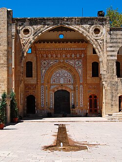
 Beiteddine Palace | |
| Coordinates: 33°41′44″N 35°34′45″E / 33.69556°N 35.57917°E | |
| Country | |
| Governorate | Mount Lebanon |
| District | Chouf |
| Area | |
| • Total | 2.44 km2 (0.94 sq mi) |
| Elevation | 860 m (2,820 ft) |
| Time zone | UTC+2 (EET) |
| • Summer (DST) | UTC+3 (EEST) |
| Dialing code | +961 |

Beit ed-Dine (Arabic: بيت الدين), also known as Btaddine (Arabic: بتدين) is a small town and the administrative capital of the Chouf District in the Mount Lebanon Governorate in Lebanon. The town is located 45 kilometers southeast of Beirut,[1] and near the town of Deir el-Qamar from which it is separated by a steep valley. It had 1,613 registered voters in 2010 and its inhabitants are predominantly Christians from the Maronite, Melkite and Greek Orthodox denominations.[2] Beit ed-Dine's total land area consists of 244 hectares and its average elevation is 860 meters above sea level.[1]
The town is well known for the Beiteddine Palace, which hosts the annual summer Beiteddine Festival.
- ^ a b "Beit Ed Dine". Localiban. Localiban. 2008-01-10. Archived from the original on 2016-03-22. Retrieved 2016-04-01.
- ^ "Elections municipales et ikhtiariah au Mont-Liban" (PDF). Localiban. Localiban. 2010. p. 19. Archived from the original (pdf) on 2015-07-24. Retrieved 2016-02-12.
© MMXXIII Rich X Search. We shall prevail. All rights reserved. Rich X Search
