Back Бэл (Ньюфаўндленд і Лабрадор) Byelorussian Bell Island (pulo sa Kanada, Newfoundland and Labrador, lat 47,63, long -52,96) CEB Bell Island (Neufundland) German Île Bell (Terre-Neuve-et-Labrador) French Isola Bell Italian Bell Island (Conception Bay) Dutch Bell Island (Newfoundland og Labrador) NB Белл-Айлэнд Russian Bell Island, Newfoundland (Conception Bay) Swedish
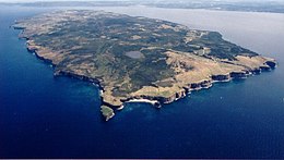
 Aerial view of Bell Island | |
| Geography | |
|---|---|
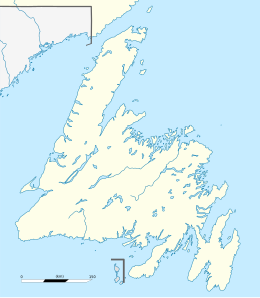
| Location | Conception Bay, Newfoundland |
| Coordinates | 47°37′58″N 52°57′57″W / 47.63278°N 52.96583°W |
| Area | 34 km2 (13 sq mi) |
| Coastline | 27 km (16.8 mi) |
| Highest elevation | 148 m (486 ft) |
| Administration | |
Canada | |
| Province | Newfoundland and Labrador |
| Demographics | |
| Population | 2,079 (2021)[1][2] |
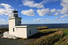
| Bell Island Lighthouse | |
 | |
| Constructed | 1966 |
| Construction | wooden tower |
| Height | 9 m (30 ft) |
| Shape | quadrangular tower atop a 1-storey fog signal building[3][4] |
| Markings | white tower, grey metallic lantern |
| Operator | Canadian Coast Guard |
| Focal height | 53 m (174 ft) |
| Range | 17 nmi (31 km; 20 mi) |
| Characteristic | Fl W 6s |
Bell Island is an island that is part of Newfoundland and Labrador, Canada's easternmost province. With an area of 34 square kilometres (13 sq mi), it is by far the largest island in Conception Bay, a large bay in the southeast of the island of Newfoundland. The provincial capital of St. John's is less than 20 kilometres (12 mi) to the east.
The coastline of Bell Island consists almost entirely of cliffs that tower up to 45 metres (148 ft) above the surf and also has several special rock formations. The island is home to four settlements with a total of over 2,000 inhabitants. The vast majority of them live in the main settlement of Wabana,[5] which can be reached from Newfoundland via a ferry connection to Portugal Cove.[6][7] To the south are the hamlets of Lance Cove, Bickfordville and Freshwater.
From 1895 to 1966, large-scale iron ore mining took place on Bell Island. As a result, the relatively small island acquired great international economic importance as it quickly grew into one of the most important iron ore producers in the world. In addition, the ore mined in the mines of Bell Island was very important to the Allied war industry during World War II, which led to Nazi Germany attacking twice. At its peak, more than 12,000 people lived there.
Since the end of mining, the population has fallen dramatically and there has been a severe economic downturn. Due to the few remaining jobs, the majority of residents now commute daily via ferry to the St. John's Metropolitan Area. In recent years, the local economy has turned to tourism to a significant extent, with the natural beauty, mining history and shipwrecks being the main draws.
- ^ Cite error: The named reference
C21Wwas invoked but never defined (see the help page). - ^ Cite error: The named reference
C21SNOwas invoked but never defined (see the help page). - ^ Rowlett, Russ. "Lighthouses of Canada: Southeastern Newfoundland". The Lighthouse Directory. University of North Carolina at Chapel Hill. Retrieved 2017-02-06.
- ^ List of Lights, Pub. 110: Greenland, The East Coasts of North and South America (Excluding Continental U.S.A. Except the East Coast of Florida) and the West Indies (PDF). List of Lights. United States National Geospatial-Intelligence Agency. 2016. p. {{{page}}}.
- ^ "Population and dwelling counts: Canada, provinces and territories, census divisions and census subdivisions (municipalities), Newfoundland and Labrador". Statistics Canada. February 9, 2022. Retrieved March 15, 2022.
- ^ Whiffen, Glenn (November 6, 2017). "Sending Legionnaire away not an option, Bell Island protesters say". www.saltwire.com. Retrieved 2021-07-27.
- ^ "N.L. ferries made 4,100 trips with no passengers last year". CBC. 2020-05-15. Retrieved 2020-12-17.
© MMXXIII Rich X Search. We shall prevail. All rights reserved. Rich X Search
