| Belle Isle State Park, Virginia, USA | |
|---|---|
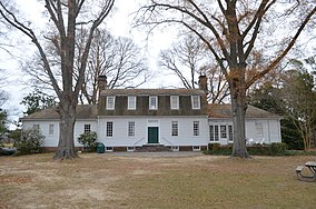
 2012 photo of Bel Air Mansion on park grounds | |
Location of Belle Isle State Park in Virginia | |
| Location | Lancaster County, Virginia |
| Coordinates | 37°46′28″N 76°35′58″W / 37.77444°N 76.59944°W |
| Area | 892 acres (361 ha)[1] |
| Governing body | Virginia Department of Conservation and Recreation |
Belle Isle State Park is located in Lancaster County, Virginia, on the Rappahannock River. It sits between Deep Creek and Morattico Creek and is currently under public ownership. The park has an area of 892 acres (3.61 km2)[1] and has facilities for camping, fishing, boating and picnics. As of 2015, the yearly visitation was 44,502.[2]
The park is a peninsula surrounded by Tidewater coastal marshes. Wildlife observed includes blue herons, osprey, hawks, bald eagles, white-tailed deer and various reptiles and amphibians. It is near the unincorporated towns of Litwalton, Morattico and Somers.[3]
- ^ a b "Belle Isle State Park". Virginia State Parks. Virginia Department of Conservation and Recreation. Retrieved April 7, 2024.
- ^ "Bell Isle State Park Master Plan Executive Summary" (PDF). Virginia Department of Conservation and Recreation. 2017. Retrieved April 7, 2024.
- ^ Kobell, Rona (October 17, 2013). "Get away from it all, including crowds, at VA Northern Neck's Belle Isle". Bay Journal. Chesapeake Media Service. Archived from the original on July 16, 2017. Retrieved April 7, 2024.
© MMXXIII Rich X Search. We shall prevail. All rights reserved. Rich X Search

