Back Aeropuertu Internacional Tancredo Nieves AST Belo Horizonte (tugpahanan) CEB Flughafen Belo Horizonte–Confins German Aeropuerto Internacional Tancredo Neves Spanish فرودگاه بینالمللی تانکردو نوس Persian Aéroport international de Belo Horizonte/Confins French Aeroporto de Belo Horizonte Galician Bandar Udara Internasional Tancredo Neves ID Aeroporto di Belo Horizonte-Tancredo Neves Italian タンクレド・ネヴェス国際空港 Japanese
Belo Horizonte/Confins–Tancredo Neves International Airport Aeroporto Internacional Belo Horizonte/Confins–Tancredo Neves | |||||||||||
|---|---|---|---|---|---|---|---|---|---|---|---|
 | |||||||||||
 | |||||||||||
| Summary | |||||||||||
| Airport type | Public | ||||||||||
| Operator |
| ||||||||||
| Serves | Belo Horizonte | ||||||||||
| Location | Confins, Brazil | ||||||||||
| Hub for | Azul Brazilian Airlines | ||||||||||
| Focus city for | Gol Transportes Aéreos | ||||||||||
| Time zone | BRT (UTC−03:00) | ||||||||||
| Elevation AMSL | 829 m / 2,721 ft | ||||||||||
| Coordinates | 19°37′28″S 043°58′19″W / 19.62444°S 43.97194°W | ||||||||||
| Website | site | ||||||||||
| Map | |||||||||||
| Runways | |||||||||||
| |||||||||||
| Statistics (2023) | |||||||||||
| |||||||||||
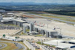
Belo Horizonte/Confins–Tancredo Neves International Airport, formerly called Confins International Airport, is the primary international airport serving Belo Horizonte, located in the municipality of Confins. Since 2 September 1986, the airport is named after Tancredo de Almeida Neves (1910–1985), President-elect of Brazil.[5]
It is operated by BH Airport S.A.
- ^ "Estatísticas e Publicações". BH Airport (in Portuguese). Retrieved 18 January 2024.
- ^ "Aeroporto Internacional de Belo Horizonte". BH Airport (in Portuguese). Retrieved 12 May 2022.
- ^ "Lista de aeródromos públicos". ANAC (in Portuguese). Retrieved 12 May 2022.
- ^ "Tancredo Neves (SBCF)". DECEA (in Portuguese). Retrieved 21 December 2023.
- ^ "Lei nº 7.534, de 2 de setembro de 1986". Presidência da República (in Portuguese). 2 September 1986. Retrieved 26 October 2023.
© MMXXIII Rich X Search. We shall prevail. All rights reserved. Rich X Search

