Back बेतिया ANP बेतिया Bihari বেতিয়া Bengali/Bangla বেত্তিয়া BPY Bettiah (ciutat) Catalan Bettiah CEB Bettiah German Bettiah Esperanto Bettiah Spanish Bettiah French
This article possibly contains original research. (May 2016) |
Bettiah | |
|---|---|
City | |
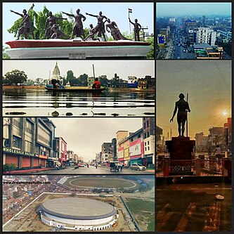
 Anticlockwise from top left -Bettiah Raj mahal Saheed Park, Sagar pokhra and Shiv Mandir, Supriya Cinema road, Bettiah auditorium and Maharaja Stadium, Gandhi statue at Hariwatika Chowk, Aeria view of Station chowk. | |
| Coordinates: 26°48′05″N 84°30′10″E / 26.80139°N 84.50278°E | |
| Country | |
| State | Bihar |
| District | West Champaran |
| Founded by | Gangeshwar Dev |
| Government | |
| • Type | Mayor-council |
| • Body | Bettiah Municipal corporation |
| Area | |
| • City | 24 km2 (9 sq mi) |
| • Urban | 64 km2 (25 sq mi) |
| Elevation | 65 m (213 ft) |
| Population (2020)as estimated[1] | |
| • Rank | 14th(as in 2011)in Bihar |
| • Urban | 414,453 |
| Language | |
| • Official | Hindi[2] |
| • Additional official | Urdu[2] |
| • Regional | Bhojpuri[3] |
| Time zone | UTC+5:30 (IST) |
| PIN | 845438 |
| BTH | 06254 |
| ISO 3166 code | IN-BR |
| Vehicle registration | BR-22 |
| Sex ratio | 53% male : 47% female ♂/♀ |
| Lok Sabha constituency | Paschim Champaran/was before Bettiah |
| Vidhan Sabha constituency | Bettiah |
| Website | westchamparan |
Bettiah is a city and the administrative headquarters of West Champaran district (Tirhut Division)[4] - (Tirhut). It is near the Indo-Nepal border, 225 kilometres (140 mi) northwest of Patna, in the state of Bihar, India.
- ^ Cite error: The named reference
Upgradationwas invoked but never defined (see the help page). - ^ a b "52nd Report of the Commissioner for Linguistic Minorities in India" (PDF). nclm.nic.in. Ministry of Minority Affairs. Archived from the original (PDF) on 25 May 2017. Retrieved 23 March 2019.
- ^ "Bhojpuri". Ethnologue. Retrieved 8 September 2020.
- ^ "Tirhut Division". tirhut-muzaffarpur.bih.nic.in. Archived from the original on 16 March 2015.
© MMXXIII Rich X Search. We shall prevail. All rights reserved. Rich X Search
