Back Bibracte ALS Бібракта Byelorussian Бибракте Bulgarian Bibracte Breton Bibracte Catalan Bibracte Czech Bibracte Welsh Bibracte German Bibracte Esperanto Bibracte Spanish
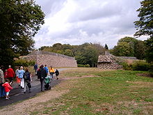
 Walls of Bibracte | |
| Alternative name | Mont Beuvray |
|---|---|
| Location | Near Autun, France |
| Region | Gaul |
| Coordinates | 46°55′23″N 4°02′15″E / 46.92306°N 4.03750°E |
| Type | Oppidum |
| History | |
| Periods | Iron Age Europe |
| Cultures | Aedui |

Bibracte, a Gallic oppidum (fortified settlement), was the capital of the Aedui and one of the most important hillforts in Gaul. It was located near modern Autun in Burgundy, France. The material culture of the Aedui corresponded to the Late Iron Age La Tène culture.
In 58 BC, at the Battle of Bibracte, Julius Caesar's armies defeated the Helvetii 16 miles south of the fort. In 52 BC, Vercingetorix was proclaimed head of the Gaulish coalition at Bibracte. A few decades after the Roman conquest of Gaul, Bibracte was abandoned in favour of Autun, 25 kilometres away. Once abandoned, Bibracte remained undisturbed and unexamined until discovered by modern archaeology.
Jacques-Gabriel Bulliot initiated the first excavations at the site between 1867 and 1895. His nephew Joseph Déchelette, author of a famous Manuel d'Archéologie, continued the excavations between 1897 and 1907.
The modern site, known as Mont Beuvray, is generally identified as ancient Bibracte. The site straddles the borders of the French départements of Nièvre and Saône-et-Loire in Burgundy. The site is an archaeological park at the centre of a protected forest. It is the focus of cooperative European archaeological efforts, a training ground for young archaeologists, and a centre for interpreting Gaulish culture for a popular audience. Important international excavations have been undertaken at Mont Beuvray by teams from the universities of Sheffield, Kiel, Budapest, Vienna and Leipzig.
On December 12, 2007, the site of Bibracte received the "Great Site of France" designation.
Before the Roman conquest in 52 BC the great Celtic city of Bibracte had more than thirty thousand inhabitants,[1] protected by a huge stone wall of the Murus Gallicus type which enclosed an area of 135 hectares.[2]
- ^ Maschner, H.D.G.; Southern Illinois University at Carbondale. Center for Archaeological Investigations (1996). New Methods, Old Problems: Geographic Information Systems in Modern Archaeological Research. Center for Archaeological Investigations, Southern Illinois University at Carbondale. ISBN 9780881040791. Retrieved 2015-06-27.
- ^ McIntosh, J. (2009). Handbook to Life in Prehistoric Europe. Oxford University Press. p. 158. ISBN 9780195384765. Retrieved 2015-06-27.
© MMXXIII Rich X Search. We shall prevail. All rights reserved. Rich X Search
