Back جبال بترروت ARZ Bitterroot Mountains BAR Битеррут Bulgarian Muntanyes Bitterroot Catalan Bitterroot Mountains German Monts Bitterroot French Bitterroot Mountains LLD Bitterroot Mountains Dutch
| Bitterroot Mountains | |
|---|---|
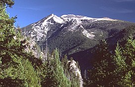
 Trapper Peak, in the Central Bitterroot Range | |
| Highest point | |
| Peak | Trapper Peak |
| Elevation | 10,157 ft (3,096 m) |
| Coordinates | 45°53′23.43″N 114°17′52.11″W / 45.8898417°N 114.2978083°W |
| Dimensions | |
| Area | 4,862 sq mi (12,590 km2) |
| Geography | |
| Country | United States |
| States | Montana and Idaho |
| Parent range | Bitterroot Range |
The Northern and Central Bitterroot Range, collectively the Bitterroot Mountains (Salish: čkʷlkʷqin[1]), is the largest portion of the Bitterroot Range, part of the Rocky Mountains and Idaho Batholith, located in the panhandle of Idaho and westernmost Montana in the northwestern United States. The mountains encompass an area of 4,862 square miles (12,593 km2).
The mountains are bordered on the north by Lolo Creek, to the northeast by the Clark Fork, on the south by the Salmon River, on the east by the Bitterroot River and Valley, and on the west by the Selway and Lochsa Rivers.[2] Its highest summit is Trapper Peak, at 10,157 feet (3,096 m).
- ^ Nkwusm (2006), Intro to the Salish Language C, Series 1 Part 2, archived from the original on February 1, 2013, retrieved May 3, 2013
- ^ "Bitterroot Mountains". Canadian Mountain Encyclopedia. Bivouac.com. Retrieved 4 March 2007.
© MMXXIII Rich X Search. We shall prevail. All rights reserved. Rich X Search