Back نهر بلاكستون ARZ Blackstone River (suba sa Tinipong Bansa) CEB Blackstone River German Blackstone River French Blackstone (fiume Stati Uniti d'America) Italian ブラックストーン川 (アメリカ合衆国) Japanese Blackstone (rzeka w Stanach Zjednoczonych) Polish Блэкстон (приток Провиденса) Russian
This article's Pollution and remediation efforts section's tone or style may not reflect the encyclopedic tone used on Wikipedia. (March 2023) |
| Blackstone River | |
|---|---|
 The Blackstone River in Massachusetts | |
 | |
| Location | |
| Country | United States |
| State | Massachusetts, Rhode Island |
| Region | New England |
| Physical characteristics | |
| Source | |
| • location | Worcester, MA |
| Mouth | |
• location | Seekonk River, at Pawtucket Falls in Pawtucket, Rhode Island |
• coordinates | 41°52′38″N 71°22′56″W / 41.8771°N 71.3822°W |
| Length | 48 mi (77 km) |
| Basin size | 540 sq mi (1,400 km2) |
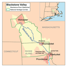
The Blackstone River in the United States flows through the states of Massachusetts and Rhode Island. It is 48 mi (77 km) long with a drainage area of 540 sq mi (1,400 km2) and drains into the Seekonk River at Pawtucket, Rhode Island. Its long history of industrial use has caused significant pollution, with the United States Environmental Protection Agency describing it as “the most polluted river in the country because of high concentrations of toxic sediments.”[1]
- ^ "Blackstone River Watershed". Rhode Island Rivers Council. Archived from the original on 2012-03-16. Retrieved 2010-12-28.
© MMXXIII Rich X Search. We shall prevail. All rights reserved. Rich X Search