Back بلانشستر (أوهايو) Arabic Blanchester Catalan Blanchester CEB Blanchester, Ohio Welsh Blanchester (Ohio) Spanish Blanchester (Ohio) Basque Blanchester (Ohio) French Blanchester, Ohio HT Blanchester Italian Blanchester (Ohio) LLD
Blanchester, Ohio | |
|---|---|
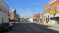
 Looking west at the intersection of Main and Broadway Streets in Blanchester | |
 Location of Blanchester, Ohio | |
 Location of Blanchester in Clinton County | |
| Coordinates: 39°17′32″N 83°59′09″W / 39.29222°N 83.98583°W | |
| Country | United States |
| State | Ohio |
| Counties | Clinton, Warren |
| Government | |
| • Mayor | John M. Carman |
| Area | |
| • Total | 4.18 sq mi (10.83 km2) |
| • Land | 4.09 sq mi (10.59 km2) |
| • Water | 0.09 sq mi (0.24 km2) |
| Elevation | 971 ft (296 m) |
| Population (2020) | |
| • Total | 4,224 |
| • Estimate (2023)[3] | 4,221 |
| • Density | 1,033.27/sq mi (398.90/km2) |
| Time zone | UTC-5 (Eastern (EST)) |
| • Summer (DST) | UTC-4 (EDT) |
| ZIP code | 45107 |
| Area codes | 937, 326 |
| FIPS code | 39-06908[4] |
| GNIS feature ID | 2398131[2] |
| Website | www |
Blanchester is a village in Clinton and Warren counties in the U.S. state of Ohio. The population was 4,224 at the 2020 census. Blanchester is part of the Wilmington, Ohio Micropolitan Statistical Area, which is also included in the Cincinnati-Wilmington-Maysville, OH-KY-IN Combined Statistical Area.
- ^ "ArcGIS REST Services Directory". United States Census Bureau. Retrieved September 20, 2022.
- ^ a b U.S. Geological Survey Geographic Names Information System: Blanchester, Ohio
- ^ "Annual Estimates of the Resident Population for Incorporated Places in Ohio: April 1, 2020 to July 1, 2023". United States Census Bureau. Retrieved June 3, 2024.
- ^ "U.S. Census website". United States Census Bureau. Retrieved January 31, 2008.
© MMXXIII Rich X Search. We shall prevail. All rights reserved. Rich X Search