Back Boheemse Woud Afrikaans شومافا Arabic Selva de Bohemia AST Шумава Byelorussian Шумава BE-X-OLD Шумава Bulgarian বোহেমীয় অরণ্য Bengali/Bangla Selva de Bohèmia Catalan Šumava (kabukiran sa Nasod nga Czech) CEB Šumava Czech
| Bohemian Forest | |
|---|---|
 Großer Arber (Velký Javor) | |
| Highest point | |
| Peak | Großer Arber |
| Elevation | 1,456 m above NN |
| Dimensions | |
| Length | 100 km (62 mi) |
| Naming | |
| Native name | |
| Geography | |
| Countries | Austria, Czech Republic and Germany |
| Range coordinates | 49°06′45″N 13°08′09″E / 49.1125°N 13.1359°E |
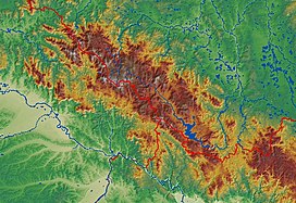
The Bohemian Forest, known in Czech as Šumava (pronounced [ˈʃumava] ) and in German as Böhmerwald, is a low mountain range in Central Europe. Geographically, the mountains extend from Plzeň Region and the South Bohemian Region in the Czech Republic to Austria and Bavaria in Germany, and form the highest truncated uplands of the Bohemian Massif, up to 50 km wide. They create a natural border between the Czech Republic on one side and Austria and Germany on the other.
© MMXXIII Rich X Search. We shall prevail. All rights reserved. Rich X Search
